Originally established as Montara Tactical Position, this site was located four miles south of the town of Montara. On 26 January 1943, the War Department acquired 135.00 leased acres from McNee Company (a ranch located at the site property) (Lease W-04-ENG-368) and 22.60 leased acres from Hibernia Savings & Loan Society (HSLS)(Lease W-04-193-ENG-368).
The site was also known as Camp Montara and Point Montara Radar Station J-80, San Mateo County, California. The site was used as a radar site by the 4th Antiaircraft Command, Western Defense Command of the Army Ground Forces. Later, all air defense radar functions were transferred to Fourth Air Force, Army Air Forces.
In the 20 March 1946 document title "Detailed Plan for the Retrenchment of Fourth Air Force Control Group Installation", the Chief, Control Group Division, Fourth Air Force recommended that this site be Retained. It also recommend that this station also perform the Identification Friend or Foe (IFF) mission. Assigned to the San Francisco Control Group. On 28 February 1947, the station was manned by a detachment of Squadron B, 412th Army Air Forces Base Unit (Western Aircraft and Control Group). Inactivated 8 April 1947 and its equipment transferred to McClellen Field in Sacramento.
Both leases were terminated in November 1947. U.S. Army Corps of Engineers real estate record do not indicate if restoration was required. The site is currently owned by the State of California Department of Parks and Recreation and by several private property owners.
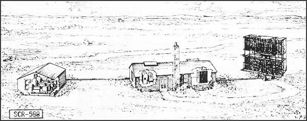
DESCRIPTION: Fixed medium-range, long wave aircraft detector and ground controlled intercept (GCI). Provides azimuth, range, and altitude data. Type HR and PPI scopes.
USES: To give continuous plan position and accurate relative height of enemy plane and friendly fighter plane for GCI. Set can also be used for early warning and to give increased coverage at low angles of search. IFF equipment RC-188 is used. When operating as GCI, VHF equipment SCR-624 is required.
PERFORMANCE AND SITING: Maximum range on a medium bomber, with set on flat sea level site:
| Altitude, feet | 1000 | 5000 | 10,000 | 25,000 |
| Range*, miles | 20 | 50 | 95 | 105 |
When operating as GCI, set must be sited so that a flat unobstructed surface extends at least 1/4th mile in the height-finding sector. Good GCI sites are extremely rare. For early warning, sets should be sited between 100 and 1,000 feet above an unobstructed surface.
TRANSPORTABILITY: Set is packaged for shipment in 55 units, weighing a total of 54,000 lbs. Largest unit measures 15.3' x 3.8' x 1.8'. Total shipping space is 3500 cu. ft.
INSTALLATION: Requires a weatherproof building approximately 20' x 40' for housing radar components and a building approximately 20' x 20' for power units and switchboard. A 25' tower on concrete footing is required for support of antenna. Buildings and tower can be built by Engineers in about 3 weeks. Radar can be installed by 5 men in 2 weeks.
PERSONNEL: 8 men are operating crew. For 24-hour operation about 54 men are required to run radar, communication radio, and camp.
POWER: 4 KW at 230 volts and 1 KW at 115 volts, from three PE-198 electric diesel units, supplied with set. (Two units operate simultaneously). Fuel consumption is 2-1/2 gallons of Diesel fuel oil per hour.