Historic California Posts, Camps,
Stations and Airfield
False Cape Radar Site B-72
(Cape Mendocino Radar Site B-72)
This World War II air
defense radar site was located off of Bear River Ridge Road between
the communities of Capetown and Ferndale in Humboldt County.
The grid coordinates are 40°29'52.4"N
124°17'39.9"W.
The radar site was garrisoned by a detachment
of the Fourth Air Force, San Francisco Control Group's 653rd
Signal Aircraft Warning Company that operated the SCR-270 and
SCR 271 series radar sets.
Extract, War
Department Inventory of Owned, Sponsored and Leased Facilities,
1945
Capacity:
Enlisted:
Permanent:
Mobilization:
Theater of Operations:
Hutments:
66
Tents:
Total: 66
Officers:
Station Hospital:
Acreage
Owned:
Leases:
6 acres (one lease)
Total:
6 acres
Storage:
Covered:
Open:
Cost to Government Since 1 July 1940:
Annual lease payments: $1.00
Land:
Construction:
$26,000.00
Total (less annual leases): $26,000.00
Remarks:
Radar Systems
at the Jenner Radar Station:
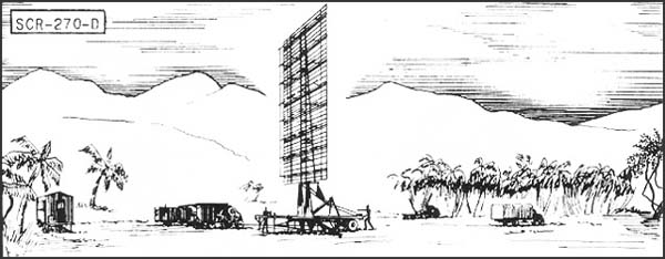
SCR-270-D Mobile Long Wave
Aircraft Warning Set
Description:
Six-vehicle mobile, long wave early warning aircraft detector.
Azimuth and range supplied. Set is equipped with "A"
scope.
Uses:
To establish a screen of warning which provides information of
approaching aircraft as early as possible but with a sacrifice
of accuracy in range, azimuth and elevation. IFF equipment RC-150
is used.
Performance and Siting: Maximum range on a single bomber flying at indicated
heights, when set is on a flat sea level site:
Altitude, feet
1000
5000
20,000
25,000
Range, miles
20
50
100
110
Set should be sited at a height between
100' and 1000' above an unobstructed reflecting surface.
Transportability:
Complete set is carried in 6 vehicles, the largest of which measures
30'4" x 9'10" x 8'. Total weight of shipment is 101,790
lbs; total volume 11,485 cu. ft.
Installation:
Operates from trucks in which mounted. Can be placed in operation
about 6 hours after arrival at site.
Personnel: Seven
men comprise operating crew. For 24 hour operation about 50 men
are required to run radar, communication radio, and camp.
Power: 15.3
KW, supplied by PE-74, 25 KVA gasoline-driven generator, having
fixed consumption of 4 gal. per hour, non-leaded gasoline.
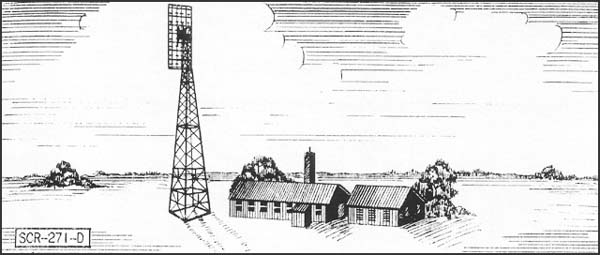
SCR-271-D and SCR-271-E Fixed
Long Wave Aircraft Warning Set
Description: Fixed
long wave early warning aircraft detector. Azimuth and range
supplied on "A" scopes. 271-D has a 100' tower; 271-E,
a 50' tower.
Uses: To
establish a screen of warning which gives data on aircraft as
early as possible, but with a sacrifice of accuracy in range,
azimuth and elevation. IFF equipment RC-151 is used.
Performance and Siting: Maximum range on a single medium bomber flying
at indicated altitudes, when set is on a flat sea level site:
Altitude, feet
1000
5000
20,000
25,000
SCR-271-E Range, miles
20
50
100
110
SCR-271-D Range, miles
25
60
120
135
Sets should be sited so that the mean
antenna height is between 100 and 1000 ft. above an unobstructed
flat surface. The 100' tower should be used when it is desired
to get additional low coverage, or to insure clearance above
surrounding trees or other obstructions.
Transportability: Sets are packed in 106 units, weighing a total
of 42,279 lbs. Largest unit is 176" x 25" x 20".
Total volume is 4008 cu. fit.
Installation: Requires
a weatherproof building approx. 20' x 40' for housing radar components
and a building approx. 20' x 20' for housing the power units
and switchboard. A 100 foot tower on concrete footings is required
for an SCR-271-D and a 50-ft. tower for an SCR-271-3. Buildings
and tower are built by engineers in about 3 weeks. Radar can
be installed by five men in about two weeks.
Personnel: 7
men are operating crew. For 24 hour operations, about 50 men
are required for radar, communication radio, and camp.
Power: 15.3
KW supplied by PE 74, 25 KVA gasoline-driven generator. Consumption
is 4 gal. per hour, non-leaded standard commercial gas.
Search
our Site!
Questions and comments concerning
this site should be directed to the Webmaster