San Diego was the first
European settlement in Alta California but the over-riding goal
of the Spanish government was the location and settlement of the
Bay of Monterey. It was to that end that the best Spanish personnel
were collected and sent by ship and ground parties to Alta California
on what was referred to as the "Sacred Expedition".
Once the location of the Bay of Monterey was verified by new latitude
measurements and comparisons with the charts prepared by Vizcaino
in 1602, the effort began to find a location for the presidio
and to build the first structure. The leader in all of this was
the Spanish Royal Corps of Engineer, Miguel Costanso, one of the
best available in Mexico at the time.
As mentioned earlier the
Spanish were the epitome of civic organization. As a means to
this end King Philip V organized the Royal Corps of Engineers
in 1711 as a Department of the Army. Its purpose was to support
the Army in its campaigns but also to provide construction drawings
of all civic buildings as well as forts, prepare maps and support
explorations of new lands for the crown. At any time there were
several hundred engineers training in the Royal Corps of Engineers.
Shortly after arrival in
San Diego in 1769, Costanso had been promoted to Lieutenant and
"extraordinary." In Mexico after the "Sacred Expedition",
he was raised in army rank to Captain in recognition of his services.
Costanso spent a little
over three months in Monterey and kept busy during that time.
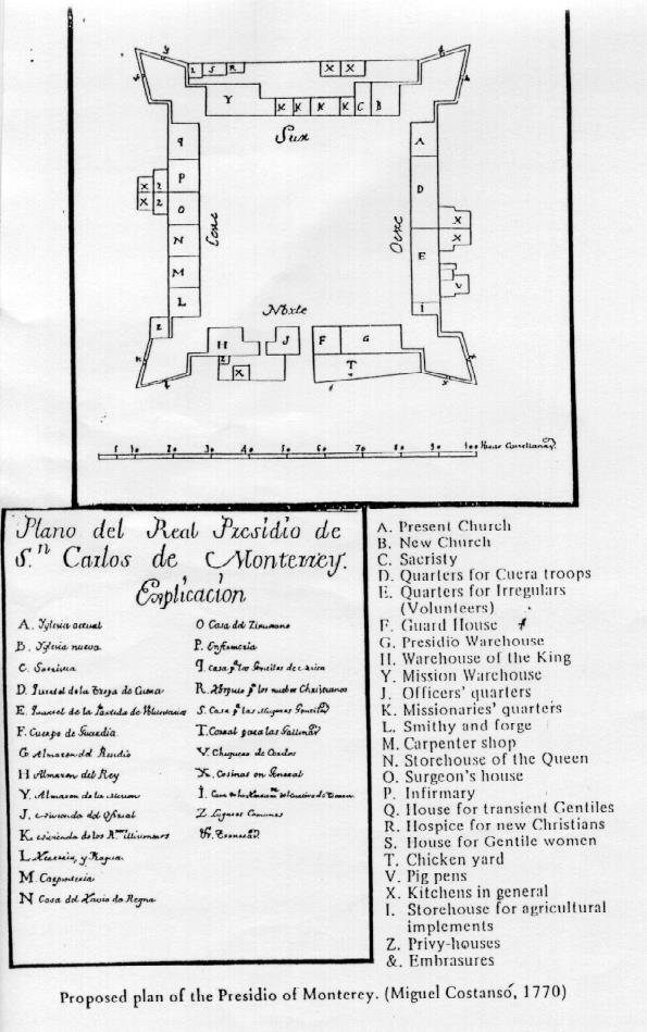
He chose the site for the Presidio of San Carlos de Monterey,
as well as for the mission, its outbuildings and offices. He utilized
his architectural skills in tracing out lines for the foundations
of the buildings and defense works. Costanso supervised the construction
of a palisade, which included storehouses where cargo from the
ship was stowed and which served as provisional living quarters
for the missionaries and the commanding officer. A third storehouse
was built to hold powder and defense equipment at a safe but visible
distance from the other supplies and habitations. He also laid
out the permanent adobe presidio to replace the temporary palisade
made of logs, sticks and tules and left a drawing to show that
plan.
Costanso had spent fourteen
months and ten days in Alta California and in that time had been
a witness and a contributor to the first European colonization
activities in the area. He left Monterey on July 9, 1770 along
with Don Gaspar de Portola aboard the El Principe (San Antonio)
and returned to Mexico where he spent the rest of his life in
the service of the King. He died in 1814, never to return to the
pine-covered slopes and the wide spacious harbors of California
that he described so well. The immediate future of the Presidio
was left in the hands of Lieutenant Pedro Fages.
The Royal Presidio of Monterey,
founded June 3, 1770, was the principal Presidio of Alta California
and is the oldest and most historic of all Monterey sites. Since
1840, when the garrison moved to El Cuartel, it had been forgotten
until 1971 when an archaeological investigation of the site was
begun.
The term "Presidio"
is derived from a Roman ancestor, "Praesidium", meaning
a fortified garrison of troops. The Spanish generally gave the
title of "Presidio" to all their forts in America, which
were among heathen peoples. From earliest Spanish penetration
into the Southwest in the seventeenth century, the Presidios were
an important force for conquest but reached a peak of effectiveness
in the last decades of the eighteenth century. This institution
was charged with handling the problem of hostile Native Americans
not susceptible to the missionary efforts of the Roman Church
and to prevent European powers from penetrating into Alta California.
California presidios varied little in design and construction
because they were designed by the same engineer, Miguel Costanso,
who elaborated the pattern developed from the Moors. Using adobe
brick and stone, presidios were built in a quadrangular shape
with walls at least 10 feet high; the length of the sides varied
from 200 to 550 feet. On diagonal corners, bastions were placed,
raised above the defense walls with cannon embrasures. This defense
system allowed soldiers to fire at attackers down the length of
all four walls. Inside, a parallel tier of buildings was made,
the roofs of which were higher than the walls to serve as a parapet
from which to shoot. Fundamental buildings in the presidio compound
were a chapel, warehouse, barracks, smithy, jail and official
quarters. The primary outside opening was the main gate, which
afforded entry of carriages, horsemen and pedestrians.
The Europeans brought with
them iron saws and axes with which to cut down the local forests
and to use to shape the wood structures. Such implements had not
been available to the Native Americans before then.
Everything was done under
the direction of the King and/or the Viceroy. After all, the King
of Spain owned everything and everybody.
With "modern"
building techniques and his marching orders in hand, Lieutenant
Pedro Fages set out to convert the wood and tule palisade into
a modern presidio as outlined by Royal Engineer Costanso. He worked
at it for three years and on November 29, 1773, now Captain Fages,
Comandante of the Monterey Presidio, sent a report to Viceroy
Antonio Maria Bucareli describing his progress:
"The presidio is about
fifty varas square. (A varas is 2'9") At its center is a
base of adobes four varas square consisting of four steps, half
a vara in height on top of which is a cupola in the shape of a
half orange on which stands the holy cross of hewn wood, seven
varas tall whose trunk and arms are a fourth of a vara wide. The
entire base is plastered with a mixture of lime and sand.
In the wing of the presidio
on the south side facing the base is an adobe church whose foundations
are of stone set in mortar. These foundations extend two quarters
above the surface and are a vara and a half in width. Upon these
foundations rise the walls five-fourths in thickness. The church
is fifteen varas long, seven varas wide and seven varas high.
Twenty hewn beams each a palm in width and ten varas in length
have an overlay of cane and upon this rests the roof, which is
flat. This has a cover of loam. The roof has four spouts to carry
off the rainwater.
Joined to the right of the
chapel is a tower six varas square also built of adobe. It is
fifteen varas high and contains two terraces in ascending proportion
in which to hang bells. The tower is surmounted by a cupola in
the shape of a half orange and upon this rises an iron cross a
vara and a half in height which also has a weather vane to show
the direction of the wind. This tower has its foundation of stone
mortared with lime and protrudes from the ground for three-fourths
of a vara. The church and tower are plastered with lime within
and without.
To the left of the church
is an adobe dwelling for the reverend fathers who come here to
administer to our spiritual life. This dwelling is about twelve
varas long and about six varas wide. It has its small outside
corridor along its length with its pillars and wooden corbels
upon which lies the beam supporting the roof. The roof is flat
and is covered with lime. The corridor has fifteen hewn beams
ten varas in length. This building communicates with the church.
It is plastered with lime in its entirety.
Along the east wing of the
presidio there are six rooms, five of which are eight varas square,
the other eight by five varas. One is used by the mail couriers
and the blacksmith, another serves as the carpenter shop, the
third contains the gear of the muleteers, the fourth is the dwelling
of the servants and the fifth is for the use of the Native Americans
who happen to sleep at the presidio. The sixth room is used to
store building tools and field implements. All these rooms are
built of poles of pine and are plastered, their roofs being of
earth. Behind the servants' dwelling is their kitchen, eight varas
square with an inside connection. It is built of the same construction.
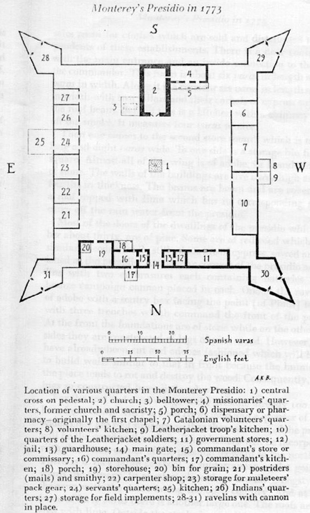
In the west wing there are two quarters for soldiers, the one
fifteen varas long and eight varas wide which is used by the volunteers
(of Catalonia). The other, twenty varas long and eight varas wide,
is used by the leather-jacket soldiers. To the rear of these quarters
are two kitchens, each four varas square for the use of the two
afore-mentioned groups. There are inside connections between the
kitchens and the respective quarters. At the head of the wing
of the presidio facing the south there is a dwelling place eight
varas square, which serves as a pharmacy containing the medicine
chest. All these constructions are the same as those in the aforementioned
wing. The two entrances to the garrisons face the plaza of the
presidio.
In the north wing there
are two storehouses for food and for royal property. Attached
to this are two small rooms occupying the space of the width of
the wing of the presidio, both of which are four varas wide and
six varas long. The first serves as a prison, the second as a
guardhouse and as sleeping quarters for soldiers (on guard duty)
with a rack for firearms inside with another outside. Next, one
comes to a large main entrance, which is four varas wide. Next
to it is a small room with its display table and shelves with
a stock of goods, made of wood. This is the store and sales room
for clothes, which are sold and distributed to the dependents
of these establishments. There is a door connecting it with the
main entrance and has inside connection to the door of the commander.
This room is about six varas in length and eight varas in width.
Along it is a corridor six varas in length and three in width
with two pillars and their corbels of cypress supporting the roof
beam. Behind this is a kitchen with a chimney to carry off the
smoke. It measures four varas square.
Then one comes to the second
storeroom, which is ten varas long and eight varas wide. To one
side is a storage bin five varas square. Almost this entire wing
is of adobe, its foundation being of stone. The walls of the building
are five varas high and three fourths in thickness. The beams
are hewn and are covered with a roof toped with lime which has
its corresponding spout to carry off the rainwater from the presidio.
Most of the doors of the
dwellings of the presidio, which number about thirty, are of pine.
Some are of redwood, which is very similar to cedar, while still
others are of cypress, sawed and fashioned at the presidio. At
the four corners of the presidio are ravelins with two embrasures
each containing batteries with a bronze campaign cannon placed
in each. One of the ravelins is of adobe with a sentry box facing
the point (of Pinos) together with three trenches, which command
the front of the presidio. At the front, the foundations are of
stone while on the other three sides they are constructed of logs
of pinewood. However, stones have already been cut and adobes
fashioned which will be used to build walls similar to that in
front because the humidity of the place tends to rot and destroy
the wood. Consequently, buildings so constructed have little advantage.
For the east and west wings
of the presidio already 100 beams have been hewn. They are ten
varas long and a quarter of a vara wide. They are roof supports
so that these sections of the presidio will be the same as the
others. The kitchens will be incorporated with them in a corner
of the presidio leeward to the northwest. There is a very large
cesspool; a subterranean outlet going towards the estuary. In
another place there are three hog stiles for the sows with the
doors facing the open country. And at a distance of forty varas
there is another large one. The roofs are covered with lime. Outside
the stockade at a distance of forty varas there are two corrals
fifty varas in circumference, which are for the cows and mules.
Next to the first is a hog sty for breeding purposes.
At about fifteen minutes
walking distance from the presidio on the other side of the estuary
is the powder magazine, (the "casa mata") four varas
square, built of poles plastered inside and out. It has its door
and lock. At a distance of four varas there is a stockade of poles
four varas high. At a musket shot away leeward to the northwest,
in which the wind prevails for the greater part of the year, is
a small house four varas square for the soldiers who stand guard.
At a distance of half a
league from the presidio is a garden 120 varas in length, its
width varying from seventy to eighty varas in places. On one side
of the garden is a house, four varas square, for two of the (Catalonian)
volunteers. It has its door and lock and a battery embrasure within
for whatever contingency may arise.
Next to the presidio on
the side in the direction of the church is where the mission of
San Carlos was founded. There it remained until May of 1771 when
an order came from His Excellency the Marquis de Croix, your predecessor,
to transfer the mission site to the banks of the Carmel River
since it is one league away from the presidio. Moreover, the site
offers better lands for cultivation than those which the port
has."
As a part of this report
Captain Fages included a drawing of the "As Built" Presidio.
An examination of this shows a number of differences with the
original Costanso proposed drawing. Notable in these changes was
the construction of the third church in the middle of the Presidio
instead of in the one side as was done at San Diego. The comandante
obviously has some flexibility in constructing the Presidio. The
use of flat roofs is more of a southwest design not really suited
to the fairly rainy weather of northern California. A "casa
mata" was also constructed at a distance from the Presidio
as at San Diego. At any rate the work accomplished in three years
by Captain Fages was very commendable. He should have received
nothing but praise; however, Fages was a soldier's soldier and
believed that the church missionaries should be under his command.
The very headstrong Junipero Serra disagreed and went off to Mexico
to plead his case.
On January 1, 1774 a reorganization
of the province of the Californias made Monterey the residence
of a captain commander with jurisdiction over the territories
of the Franciscan missions (thus resolving the struggle for supremacy
in temporal matters in favor of the military over the church)
and reporting directly to the governor of both Californias at
Loreto.
The garrison was to consist
of one captain, one sergeant, 22 soldiers, two carpenters, four
blacksmiths, four muleskinners and one storekeeper at Monterey.
An additional corporal and five soldiers were to be the guard
for the mission at Carmel where Father Serra resided. Captain
Fages, largely at the insistence of Father Serra, was relieved
of his command and sent to fight Apaches in Sonora - almost a
death sentence. In his place Don Fernando Rivera y Moncada was
appointed captain commander and arrived in Monterey on May 23,
1774 to take command. Moncada, remember, was involved with Portola
in the original "Sacred Expedition" from Loreto.
Moncada was never too popular
a comandante and it was with relief that the garrison saw him
go on February 3, 1777 as a result of still another reorganization.
Don Felipe Neve arrived on that day as Governor of the Californias
to reside in Monterey, thus making that village the capital of
both Californias. Moncada was posted as Lieutenant Governor to
Loreto, the former capital.
Neve was a more energetic
commander than Moncada had been and by July 3, 1778 had completed
the conversion of the log and earth stockade to a stone and adobe
wall twelve feet high, four feet thick and 537 yards in circumference.
Inside were ten adobe houses measuring 21 by 24 feet, and a long
barracks, 136 by 18 feet, which was not quite finished. The newer
buildings were thatched rather than roofed with sod.
By 1782 there were 205 soldiers
in the four presidios of Alta California plus a fifth presidio
with 54 men at Loreto in Baja California all under the central
direction of the captain commander at Monterey. The Monterey garrison
itself consisted of the governor, a lieutenant, an alferez (a
junior lieutenant), a surgeon, a sergeant, two corporals, 27 soldiers,
one carpenter and two blacksmiths. At each of the three missions
of Carmel, San Antonio and San Luis Obispo the garrison maintained
an additional corporal and five soldiers with four more soldiers
at the Pueblo of San Jose de Guadalupe.
On September 10, 1782, Pedro
Fages, having survived the Apache wars and now promoted to colonel
of infantry, returned to the Presidio as governor of both the
Californias.
Four years later the French
scientist, Jean Francois De La Peruse, head of an expedition funded
by King Louis XVI, arrived at Monterey with a two-ship squadron
- the L'Astrolabe and the La Boussole. The French were among the
first Europeans that wanted to know what Spain had in the new
world and just what potential there was for their country. The
British Cook Expedition had been there before them in 1780 and
1784 and had stirred up interest after their journals were published
in Europe.
La Peruse visited the Presidio
September 14 - 24, 1786. His comments, among others, were: "a
lieutenant colonel who resides at Monterey is governor of the
two Californias. His government is more than eight hundred leagues
in circumference but his real subjects are two hundred and eighty-two
cavalrymen who must furnish garrisons for five little forts and
supply squads of four or five men at each of the twenty-five missions
or parishes established in Old and New California. So small a
force suffices to control about fifty thousand nomadic Indians."
La Peruse sent his journals back to France from the South Seas
but his expedition was never to be heard of again.
On August 11, 1789 the Presidio
was badly damaged by fire as the result of firing a salute to
the ship San Carlos as it entered the port. A flaming wad from
the salute gun set fire to the thatched roofing of one of the
buildings; the fire spread to almost the entire northern side
of the Presidio and half of the buildings eventually were destroyed.
In September 1790 the Presidio was reroofed this time with the
red tile that gave the Spanish buildings their distinctive permanent
appearance.
On February 26, 1791 work
on the fourth and present chapel was started using stone instead
of the adobe used in the third chapel and the other Presidio buildings.
Viceroy Gigedo directed that the new chapel follow closely the
plan created by Antonio Velasquez, Director of the Academy of
San Carlos in Mexico. It was completed in 1794 by Native American
labor under the direction of Manuel Ruiz, a Mexican stonemason
who also completed the Carmel Mission in the same year. Father
Fermin Francisco Lasuen officially blessed the chapel on January
25, 1795. This chapel is the only building of the five presidios
to survive the ravages of time to the present, and with rebuilding,
additions and modifications over that time is the center of the
Catholic Parish in Monterey today.
In 1791, the Spanish outfitted
an expedition to explore the world and its own possessions under
the leadership of Alejandro Malaspina. This royal expedition visited
Monterey on September 1791 for a fortnight, which gave the expedition's
artist the opportunity to make the first known sketches of the
Presidio as it then appeared. A comparison of the original Presidio
plan by Costanso, Fages's earlier description and the Malaspina
expedition's sketches shows that the new buildings did not employ
the external wall as their rear wall but were separated from it
by some distance. This space may have been used as corrals for
the horses and for kitchen and latrine space. A bell tower, which
Fages had built earlier, had collapsed by this time and the bells
were suspended from a wooden rack near the adobe rubble, which
still had not been cleared away. At the time of the Malaspina
visit the local garrison consisted of the comandante (Fages was
still in charge but waiting the arrival of his successor, Jose
Romeu), a lieutenant, an alferez and 63 cavalrymen. The log of
the expedition also makes mention of a common practice at Monterey,
the firing of cannon from the shore to guide ships into the landing
area through the all too common fog. In the Malaspina log the
guns firing from the presidio are identified as "12 caliber
cannon" which were probably the equivalent of nine-pounders.


Another important commentary
on the Monterey Presidio was recorded in the logs and reports
of the next English expedition to explore the world and check
on the Spanish possessions therein. Captain George Vancouver,
a member of the earlier English Cook Expedition in 1784, led this.
His three-ship squadron arrived off Monterey on November 27, 1792.
Vancouver was an astute, although acid, military observer who criticized the location of the Presidio as unhealthy since it was located on low swampy ground; and the Presidio did not have an adequate supply of fresh water due to the indolence of the Spanish in failing to sink wells.
John Sykes of the expedition
made two drawings of the Presidio, one of which was published
in 1798 as a William Alexander rendition.
Vancouver's comments on
the Presidio are: "the buildings of the presidio form a parallelogram
or long square comprehending an area of about 300 by 250 feet.
Officers' apartments were tiled, and buildings for officers, soldiers,
and stores were along and inside a defense wall. There was one
entrance for carriages, which was the main gate. Small doors opened
to the countryside in the middle of the sidewalls, to the right
and left of the main entrance. There was one entrance to the apartment
of the commanding officer with 5 of 6 spacious rooms with boarded
floors. Windows all faced the plaza and had no glass. There were
no apertures in the wall except doors, with one at each of the
officers' houses contiguous to the governor's house, and a door
on the opposite side. There were blockhouses on each corner. (In
the Sykes drawing the bastions were outside the corners. Jose
Cardero in 1791 showed the southeast blockhouse within the walls.)
The whole presents the same lonely uninteresting appearance, as
already described at St. Francisco. On the outside, before the
entrance into the presidio, which fronts the shore of the bay,
are placed seven cannon, four nine-pounders dismounted, form the
whole of their artillery. These guns are planted on the open plain
ground, without any breast work or other screen for those employed
in working them, or the least cover or protection from the weather.
The four dismounted cannon, together with those placed at the
entrance into the presidio, are intended for a fort to be built
on a small eminence that commands the anchorage. A large quantity
of timber is at present in readiness for carrying that design
into execution; which when completed, might certainly be capable
of annoying vessels lying in that part of the bay which affords
the greatest security, but could not be of any importance after
a landing was accomplished; as the hills behind it might be easily
gained, from whence the assailing party would soon oblige the
fort to surrender; nor do I consider Monterey to be a very tenable
post without an extensive line of works."
The only other military establishment that met Captain Vancouver's critical eye in the Monterey area was at the mouth of the Salinas River where "a small guard of Spanish soldiers are generally posted, who reside on that spot in miserable wretched huts".

From the account of Archibald Menzies, the botanist who accompanied
Vancouver, it would seem that the four dismounted cannon were
already in place at the site of the future fort, for Menzies wrote
that "six nine-pounders and three smaller ones were mounted
on carriages
before the entrance to the presidio and we saw four nine-pounders
without carriages laying on logs of wood on a small eminence abreast
of the anchorage." Menzies also clarified the role of the
small guard that Vancouver had noticed: "To guard themselves
therefore from any sudden alarm, the Spaniards have outposts a
few leagues off where soldiers are stationed at the different
passes to watch the Indians' motions and give timely intimation
to the garrison in case of any hostile appearance. One of these
outposts, about five leagues to the eastward of Monterey, frequently
terminated our ride; it was guarded by 6 or 7 soldiers and situated
by a wide rivulet."
On November 1, 1793 the
Vancouver expedition paid a second visit to Monterey, at which
time he observed that, "the cannon, which, on our former
visit were placed before the presidio, were now removed to the
hill, mentioned at that time as intended to be fortified for the
purpose of commanding the anchorage. Here is now erected a sorry
kind of barbet battery, consisting chiefly of a few logs of wood,
irregularly placed behind which those cannon, about eleven in
number, are on their rear and flanks entirely open and exposed."
By a "barbet" Vancouver meant an open gun position whose
only protection was afforded by a mound of earth or pile of wood
over which the muzzle of the gun projected.
On February 16, 1792 the
new comandante Jose Joaquin Arrillaga (Romeu had died on April
9, 1792 after only six months at Monterey) reported to the viceroy
that Monterey had eleven cannon, eight guns and three pedreros.
The latter was a lighter cannon, designed to shoot stone balls
instead of iron shot, these were probably the three-pounders that
Vancouver had noticed. Arrillaga added however, that Monterey
had only one or two men at the fort to man these guns. The fort,
or El Castillo, was located on the site of the present Presidio
of Monterey, at the first level overlooking the harbor.
Removal of the cannon to
El Castillo marked the end of the Old Spanish Presidio as a true
fort and the old enclosure more and more assumed the character
of an administrative center and unfortified barracks. Recognizing
the shift in status of Monterey from a garrison to a town, Spain
established a formal pueblo government for the presidio establishments
in 1791, which went into effect in 1794.
The already flimsy fortifications
at the Presidio became progressively more decrepit with each passing
year. In February of 1801, Arrillaga informed the viceroy that
the Presidio was "in ruinous condition." The inability
of the adobe construction to withstand the elements even in such
a mild climate as that of Monterey is evident from the report
that in March of that same year the main gate of the Presidio
was demolished by a wind and rainstorm. In 1803, the Catalan volunteers
were withdrawn, reducing the local garrison to nothing but cuera
soldiers and a handful of artillerymen. In 1804 Alta and Baja
California were placed under separate governors. In 1810 the Spanish-American
Wars of Independence broke out, the most direct result of which
was that supply ships stopped coming to Monterey for a number
of years and then only sporadically thereafter. From 1810 to 1820
the Monterey garrison received no pay at all.
One of the effects of the
War for Independence from Spain was the attack of Hippolyte Bouchard,
an Argentine privateer out of the Hawaiian Islands, on Monterey
in November 1818 with the resultant conquest and sacking of the
Presidio and spiking of the guns at the Castillo. The attack was
carried out as predicted by Vancouver with a large party landing
behind the Castillo. Reconstruction work had been underway by
then Governor Sola at the Presidio even before this attack. The
damage was confined to the northern side of the Presidio and to
three houses of the southern block but left the adobe walls for
the most part still standing. The raiders took about $5,000 in
goods and the orchard and vegetable garden were entirely ruined.
The houses of the governor and comandante were among those partially
destroyed.


Reconstruction efforts continued for years. On August 18, 1826
then Governor Echeandia ordered 15,000 adobe bricks for rebuilding
parts of the Presidio. On April 9, 1822 independence of Mexico
was celebrated at the Presidio of Monterey. On November 11 of
that year, elections were held at the governor's house to select
provincial deputies.
In 1826 the English ship
H.M.S.Blossom visited Monterey. Its midshipman Richard Beechey
painted a watercolor entitled "Presidio of Monterey."
In 1827 the French explorer Auguste Bernard Duhaut-Cilly on the
ship Le Heros visited Monterey during which he prepared a sketch
of the Presidio. In 1829 Alfred Robinson, factor on the Boston
ship Brookline, prepared a sketch of the Presidio, which showed
the northern wall in complete ruin.
In 1828 to 1829 the Joaquin
Solis revolt began at the Presidio and spread to the south to
Santa Barbara. The soldiers were protesting their lack of pay
and poor living conditions. Some improvements followed a settlement
of hostilities.
In 1835 Richard Henry Dana
visited Monterey and commented, "In the center of it is an
open square, surrounded by four lines of one-story buildings.
The presidio here was entirely open and unfortified."
On November 5, 1836 the
Gutierrez-Alvarado revolt ended unceremoniously when, as Charles
Wilkes of the U.S.N. Exploring Expedition comments, "at dawn
on the 5th, their hunter adversaries becoming impatient at the
delay, fired an eighteen-pound ball, which struck the center of
the roof of the Presidio, directly over the apartment where the
council was held."
On May 14, 1840 Jose Zenon
Fernandez acquired the Presidio governor's house from Jesus Pico.
At this time the house was described as: "consisting of six
rooms with an upper story and wooden floors. And the balance without
flooring or upper story - said house has a tile roof, and stands
on a lot of 50 varas frontage by 50 varas in depth, situated at
a point where the buildings of the old presidio were, on the left
hand side as you come out of the church."
In 1840, La Casa de Gobierno
or El Cuartel, a long two-story adobe governmental building was
built by Governor Alvarado. This was the new barracks for the
soldiers.
In January 1842 the French
attaché to Mexico, Duflot de Mofras, visited Monterey and
described the ruined adobe walls: "The presidio had been
demolished...few traces of the foundations remaining...During
the wave of revolution that swept over Monterey, the presidio
was pillaged by inhabitants who used the material for building
houses. Plans, however, have been made to reconstruct the church.."
In 1842 pictures of the
city of Monterey were prepared by Edward Vischer and Swedish traveler
Waseurtz af Sandels.
By 1845 little remained
of the Presidio but the town flourished. The Presidio armament
was removed to San Juan Bautista according to H.R. Bancroft. Much
of the Presidio property was sold and resold for new developments.
The chapel, the one enduring structure of the Presidio, was restored
and stands today as a tribute to the desire of the Spanish government
to hold the line against encroachment from the European competitors.
On January 18, 1971 the
first attempts to locate the walls of the Presidio were made by
Monterey archeologist Donald M. Howard. Permission was obtained
from the Catholic Parish to conduct exploratory excavations to
locate the original Presidio compound. Students from the Pacific
Grove Community Centered High School were used to conduct preliminary
work and on February 15, 1971 a trench revealed the Presidio footing.
This discovery sparked tremendous community interest and produced
statewide publicity and television coverage.


%20of%20pm13.jpg)
Subsequent work has shown the true architectural form of the Presidio
based on fieldwork.
The Army Presidio recognized
the importance of the excavations and permission was obtained
to construct a protective shelter, which was finished by August
1972. In 1975 Howard had the Presidio site resurveyed and using
earlier field notes determined the location of the various walls
of the Presidio which were moved and expanded during the time
the Presidio was in use.
In 1983 the location of an 1820 drawing of the Monterey Presidio prepared by General Mariano Vallejo, Comandante of the Presidio in 1836, was reported. The background and reference for this drawing is given above under the San Diego Presidio story. Vallejo was a resident soldier at Monterey for years and was very familiar with the layout of the Presidio at that time. Vallejo's drawing shows the outline of the Presidio to be different than described in the written record and in some of the earlier drawings of the Presidio. The drawing probably reflects what was current construction at the height of the presidio period following the Bouchard attack. Patios separate the buildings from the outer wall. The inside square is ringed with porch roofs that are supported by posts. Only one ravelin is shown in the southwest corner. New rooms built outside the walls are located on both sides of the main gate. Also shown in the 1820 drawing are the outbuildings around the walls and the Castillo, which has three buildings and six embrasures for cannon. A cemetery is shown behind the Presidio Chapel.
References: References used for this history are based on the following: Presidio of Monterey by Antoinette G. Gay, 1940; "A Description of California's Principal Presidio, Monterey, in 1773" (M. Geiger, ed) The Historical Society of Southern California, Vol. XLIX, No.III, pgs. 327-336, 1967; A Pictorial and Narrative History of Monterey, Adobe Capital of California by Jeanne Van Nostrand, California Historical Society, 1968; A History of the Presidio of Monterey 1770-1970 by Kibbey M. Horne, Defense Language Institute West Coast Branch, Presidio of Monterey, California, 1970.; California's Lost Fortress, the Royal Presidio of Monterey by Donald M. Howard, Esq., 1976.
%20of%20pm14.jpg)
%20of%20pm15.jpg)
%20of%20pm16.jpg)
