Originally designated Hunter Liggett Military Reservation in 1941, the installation is named for Lieutenant General Hunter Liggett (1857 – 1935). General Hunter Liggett commanded the 41st National Guard Division, and later, the First Corps of the American Expeditionary Forces during World War 1. He also served as Chief of Staff for General Pershing. In 1975, the reservation was redesignated Fort Hunter Liggett Military Installation.
Fort Hunter Liggett is situated about 25 miles southwest of King City, and about 86 miles south of old Fort Ord. In 1940, in anticipation of training soldiers for combat on World War II European fronts, the War Department purchased over 200,000 acres of local ranch lands between Salinas River valley divide and the Pacific Ocean. Terrain varying from level valleys bordered by gentle hills to steep, rugged mountains has since provided opportunities for "real world" training and defense technology testing. At present, the installation encompasses approximately 165,000.
Until 1952, fort administration was under Camp Roberts authority; and, it was a sub-installation of Fort Ord until November 1993 when the installation came under United States Army Reserve Command. Fort Hunter Liggett now, as a sub-installation of Fort McCoy, WI, is operated primarily as the Army Reserve Command Western Reserve Training Center serving Active and Reserve components.
Fort Hunter Liggett's mission is to maintain and allocate training areas, airspace, facilities and ranges in order to support reserve and active components field maneuvers, live fire exercises, testing, and Institutional Training. Additionally, the installation provides quality of life and logistical support to training units.
In general, the installation is bounded on the north by the Salinas Valley, on the east by the foothills of the Santa Lucia mountains, on the south by Monterey/San Luis Obispo county line, and on the west by approximately 55 miles of Los Padres National Forest. The highest mountain in the area is Junipero Serra Peak; at 5,862 feet, it is visible toward the north and has a fairly good road leading to the summit. Formerly, the peak was known as Santa Lucia, and local long-time residents still call it by that name. In winter it is sometimes cloaked with a white mantle of snow.
Another high point in the area is Cone Peak (5,155 feet), best seen by taking Nacimiento Road to California Highway 1. This road crosses through some of the most beautiful scenery on the reservation and, once over the pass, opens onto a panoramic view of the Pacific Ocean. Six miles south of Nacimiento Road on Highway 1 is Jade Cove a rich deposit of jade available below mean high tide. A round trip to Jade Cove takes about four hours driving.
In the summer months daytime temperatures may be 120 degrees or higher but soon after sunset, temperature drops rapidly and the nights are cool and pleasant. During the long summer, humidity is very low, rain seldom falls, and streams dry up or disappear underground. During this arid period, fire danger is so great that over 800 miles of firebreaks on the installation prevent wild fires and aid in fire suppression. Winter temperatures are low and frost is not uncommon. The rainy season usually is between December and February when an average annual 13.98 inch rainfall is expected. During this period,
fertile valley soils soak up the moisture to provide abundant spring and summer wildlife feed.
Many wild animals thrive in the area, the most numerous being the California ground squirrel, rabbits and deer. Other animals include the gray tree squirrels, raccoons, wildcats, mountain lions, skunks, badgers, foxes, coyotes, opossums, wild hogs, and an occasional bear. There are also doves, pigeons, quail, wild turkey and ducks. The variety of game animals makes hunting a favorite sport for military and civilians in the area. Fishing is good in stocked ponds scattered throughout the installation.
The varied terrain and weather conditions at Fort Hunter Liggett provides unique opportunities for continuing training and testing, and makes the installation a valuable asset for future Armed Forces land use needs.
Cultural History
This same environment was the setting for a long cultural history. In a time capsule, Fort Hunter Liggett’s history largely reflects the history of the state of California. Fort Hunter Liggett’s protected, well-watered setting, bountiful in food and material resources supported a large prehistoric population. Speakers of a Hokan language were among the first people migrating south and west over the Sierra barrier toward the pacific Ocean. As early as 8,000-10,000 years ago, this area was the heartland of territory between Salinas Valley and the ocean, held by ancestors of people known now as the Salinan Indians.
Many thousands of years after ancestral Salinan people arrived, eighteenth century explorers and missionaries traveled through the hills and valleys. In 1771, Spanish padres established a mission on oak dotted plains bordering San Antonio River, just south of its present location. Establishment of San Antonio de Padua initiated local agrarian development that heavily impacted the area's natural resources. Mexico's 1822 independence from Spain brought a new regime to the area and mission lands were divided into large grants; five grants were wholly or partially within present Fort Hunter Liggett. The Mexican regime continued the mission's economic practice of heavy livestock grazing, irrigated and dry farming, and adobe building construction of grants encompassing vast tracts of land.
The mid-1800s gold rush and California statehood stimulated Euro-American westward crowding in pursuit of mineral wealth or soil rich farmlands. Mexican land grants were broken into small homestead parcels throughout Fort Hunter Liggett’s level stream valleys. Mining ventures explored gold and other mineral possibilities, resulting in development of a thriving mining district. The small town of Jolon rapidly grew into a large community that served the developing area.
In the late 1880s, small farms were consolidated into large cattle ranches and, in 1920, William Randolph Hearst purchased as much local land as possible. In 1940, the War Department purchased Hearst's acreage and neighboring lands.
All of these activities have left a record on the landscape, signatures of different cultures and land use. Fort Hunter Liggett not only encompasses unique natural resources but protects a number of significant cultural resources. Three are on the National Register of Historic Places.
La Cueva Pintada (The Painted Cave)
At an elevation of over 3,000 feet La Cueva Pintada (The Painted Cave) is an ancient cultural site set among some of the most picturesque scenery on the installation.
In this painted cave, centuries ago native people painted the walls with pictographs in white, red, black, and ocher colors.
The cave is really a rock shelter about 16 feet high and 21 feet wide at the entrance. Inside, the greatest width of the cave is 45 feet, and depth ranges from 15 to 20 feet. Some pictographs (paintings) are animal-like and some are geometric or linear. They are applied in layers and both under and over the soot blackening the cave ceiling.
The paintings seem related to several important aspects of local prehistoric life. Before the Indians were missionized, celebration of specific events, such as the winter solstice, involved ritual and ceremony. A boy’s entry to manhood also required ritual. Researchers think the pictographs were part of these and other rituals. Without memories of these events, these conjectures are difficult to confirm. Legend says that, after conversion to Christianity, the Indians told the Franciscan Fathers where the cave was so that they might go there and destroy the idols.
The pictographs and deep, hand made depressions in the cave floor cave are very old. The depressions, called bedrock mortars, are the result of grinding vegetable material, or pigments with a stone, or pestle. White may have been made from limestone deposits secured near Stony Valley or from white clay; black from soot or charcoal; and red from cinnabar. Indian use of cinnabar prompted early miners to discover the source of this material. Once found, the rich deposits of cinnabar eventually yielded an abundance of quicksilver. Bedrock mortars outside the cave and along the creek next to the cave were probably used to grind acorns or grass seeds. Most of the cave floor is covered with a mineral deposit; part of the mineralization is polished and slick, probably from a long period of use.
Today La Cueva Pintada, as far as its physical condition is concerned, is pretty much as it was thousands of years ago. In 1976, La Cueva Pintada was listed on the National Register of Historic Places and is protected by Federal Laws. Prior to placement of a fence at the cave opening, vandals destroyed some of the paintings..
Mission San Antonio De Padua.
Mission San Antonio de Padua, presently preserved as an 85-acre holding within Fort Hunter Liggett, was established in 1771. The Spanish explorer, Don Gaspar de Portola, was so impressed during his autumn 1769 travels through Jolon Valley that he conveyed his enthusiasm to Father Junipero Serra. Serra, a Franciscan, was intrigued by Portola’s description of the area and he found the area perfect for a mission.
On July 14, 1771, the mission bell was hung on an oak tree about two and one half miles southeast of the present mission location. Due to a shortage of water at this site, in the summer of 1773, the mission was moved to its present location.
San Antonio was the third Mission established and most successful educating and converting local Indians to Christianity. Eventually, it became one of the most prosperous of all the Missions. After the 1834 secularization of all California Missions, San Antonio went into decline.
In 1862, the property rights of the Franciscan Order to the Mission land and buildings were confirmed in a deed signed by President Lincoln. This deed gave the Order 33 acres of land that still belongs to the Franciscans.
Disintegration of the structure was at its worst in 1890 when termite-riddled timbers failed, causing roofs to collapse. Between 1902 – 1908, members of the California Historic Landmarks League rebuilt the church walls and covered them with a wooden roof. The 1906 earthquake partially destroyed restoration work but it was quickly resumed. Restoration funding was provided by donations from private citizens, including a Hearst Foundation grant.
The Franciscan Friars returned to the Mission in 1928. Restoration of many old structures and construction of new facilities, was accomplished between 1928 and the close of the 1950’s. After War Department acquisition of neighboring land, many soldiers assisted with the restoration project during off-duty hours.
Mission San Antonio de Padua is listed on the National Register of Historic Places; new construction at Fort Hunter Liggett is designed to compliment the mission's Spanish motif.
Old Jolon
A Salinan village near the historic-period Jolon town site seems to have been the origin of the town's name. "Jolon" also is a Salinan Indian word believed to mean "Place of Meeting" from the Antoniaño or Jolon Salinan Indian language. A later translation of the Salinan word was "Place of Dead Oaks", which reflected Spanish and Mexican practices of girdling the trees and using the wood after the trees died.
Jolon was founded, around 1860, on the banks of Jolon Creek, near the most traveled route between Spanish and Mexican settlements, El Camino Real. This major route became a stage road bringing mail and goods and finally, settlers to the area. In 1858, Francis Sylvester petitioned for a post office. Although the actual location is not clear, it is known that a local ranch house served as post office. By 1878, Jolon post office was established in Dutton-Tidball Hotel.
In 1875, James R. Bolton acquired a considerable amount of land that was being parceled off and sold. In 1883, Mr.. Bolton sold two acres (more or less) to the Right Reverend William Ingraham Kip, Bishop of the Protestant Episcopal Church. Saint Luke's Episcopal Church of Jolon was built in that area, on its present site.
The early 20th Century saw much growth and prosperity for Jolon. In addition to the two hotels, there were three saloons, two blacksmith shops, two stores, a large dance hall, a jail, and two "China Towns" for the Chinese who panned gold. The Gold Rush and the great Ruby Gold Mining and Land Company spurred brief local development.
With the purchase of the surrounding land by William Randolph Hearst Jr., Jolon went into decline, and was a ghost town by the time the Army took over the land for the military reservation. In 1929, the town of Jolon burned to the ground leaving only the Dutton Hotel, the Tidball Store, the school, and Saint Luke's Church.
The Hacienda
One of the most notable and certainly the most visible National Register property is Milpitas Ranch house, better known as the "Hacienda".
Shortly after the turn of the century Hearst Jr. began buying up properties in the Santa Lucia's. Hearst Sunical Land and Packing Corporation included James Brown Cattle Company which owned most of the large Rancho Milpitas. In 1923, the Dutton estate was sold to Hearst and by the time of the US government purchase, Hearst had succeeded in buying nearly the whole of Ranchos Milpitas, Los Ojitos, El Piojo, and San Miguelito, as well as most of Jolon.
Hearst commissioned Julia Morgan to design and construct the Milpitas Ranch headquarters. In 1929, construction of the complex began on the site of the original Milpitas Ranch House that recently had burned. A south wing originally in the designs and intended to be Hearst's private quarters was never completed. Julia Morgan and Hearst correspondence indicates that original Hacienda plans were to house 20 employees; these plans were expanded to house 30 employees. Construction cost reached $200,000.
Ms. Morgan's design reflected California mission style but was innovative in that the structure is made entire of poured concrete. Stan Woods transported the construction material in trucks from Santa Cruz to the site. Very little material was wasted. Form wood to create the structure, including the large supporting beams and archways, was recycled for use in the ceilings. Reportedly, the Hacienda's massive concrete arches, long shaded corridors, and red clay tile roof, lead early visitors to mistake the Hacienda for neighboring San Antonio Mission.
Wood stoves and fireplaces provided heat. There was no electricity. A well located by the San Antonio River provided water to a tank located in the tower above the kitchen area. Although, the Hacienda was built to house the ranch manager, mechanics, gardeners, and cooks needed to care for the ranch year round, reportedly, the cowboys camped in the fields, and never stayed in the Hacienda. Other employees stayed at many other farm sites, such as the San Miguelito and El Piojo ranches, Hearst had purchased along with Milpitas Ranch.
Throughout the 1930's, the Hacienda was used as Milpitas Ranch headquarters. It was never used as a hunting lodge because Mr.. Hearst did not allow hunting on his property, nor was there ever a wine cellar located in the Hacienda.
Harry Taylor was ranch manager and William Harrison, a ranch foreman supervised fencing, hay, and tractor crews. These crews harvested wheat, barley, oats, and alfalfa crops. Edgar Wharff, owner of Los Ojitos Ranch, worked for Hearst after his father, Prentice, sold their ranch to Hearst. Wharff was cattle foreman with Bob Vasquez.
The murals painted on interior Hacienda walls were painted in 1957 by Bill Runyan. Mr.. Runyan first came to the Jolon area as a soldier, then remained as a civil service carpenter and to finish the mural he began painting as a soldier. The small ornamental paintings, particularly in the center guest quarters, were done during the Hearst era and touched up or repainted by the Army.
An aircraft landing strip was built down slope and slightly to the left of the Hacienda. A Stinson Tri-motor was one type of plane Mr.. Hearst flew. Hearst's Hacienda guests included many famous people: Marion Davies, Dick Powell, Will Rogers, Jean Harlowe, and Errol Flynn. Local residents remember fiestas with Marichi bands playing from the dining room balcony.
On December 12, 1940, the Hearst era ended when the approximately 158,000-acre ranch was sold to the government. Other landowners sold 108,950 acres so that the War Department encompassed a total of 266,950.11 acres within the Reservation.
The Tin Barn
The Fort Hunter Liggett Fire Department, better known as the "Tin Barn,” originally was constructed in San Francisco for the 1915 Pan Pacific Exposition celebrating the Panama Canal opening. Following the exposition, Brown, the ranch owner before Hearst, bought the barn and had it brought by rail to King City; from there, horse and wagon brought it to its present site.
Originally it was a horse barn, but over the years it served a variety of purposes. In 1940, the Army used it to store engineering equipment, then it was the Post Exchange where a snack bar, clothing store, barber shop, laundry, and library served the installation. It was the post theater, a gymnasium and, finally, the fire department.
Fort Hunter Liggett Cemeteries
Several historic-period cemeteries located on Fort Hunter Liggett. One of the most interesting cemeteries is located near the original San Antonio Mission site. Local citizens think this may be the original mission cemetery that was a community cemetery before Saint Luke's Episcopal Church was established at Jolon. N.E. Adams, a member of Company B of the 2nd California Cavalry, is buried here. He was a private who enlisted at San Francisco on September 14, 1861, deserted at Camp Albert on January 25, 1862, surrendered on April 25, 1865, and mustered out with his company at Sacramento on June 13, 1866.
Among military buried at Saint Luke's Episcopal Church Cemetery, is Evelyn Dutton, Company L, 4th Tennessee Cavalry. Military personnel at the Pleyto Cemetery include Sergeant J. McCandless, Company L, 17th Kentucky Cavalry, and Lieutenant Jon McElheny, Company A, 6th Missouri Infantry.
Tiburcio Vasquez – Bandit
Many legends surround the various cultural transitions that have taken place locally. There are tales of ghosts at the mission, a headless horsewoman, and even buried treasure. The story of Tiburcio Vasquez, although it focuses on a real person, also is surrounded with the mystic of the isolated, mountainous terrain.
In 1875, after a colorful life, Vasquez was hanged at San Jose. Some stories denounce Vasquez as a horse thief and bandit, others praise him as a sort of "Robin Hood" of the Mexican and Spanish Californios as well as the “Americanos”.
At the age of 17 he started a fight in a Monterey dance hall when “Americanos” invaded the dance of some young Californios and their black-eyed senoritas. The intruders shoved and snatched the girls from their escorts’ arms, even as the dance continued. In the ensuing free-for-all, lamps were shot out. In the moonlight, the glint of a knife
flashed and one of the uninvited lay dead.
Vasquez fled from the hall and hid in the hills. He was tracked down and captured. but no evidence could be produced to prove him guilty in court, and he went free. From that time, however, he was suspect; he tried ranching many miles from Monterey, but suspicion and distrust always followed. When a horse or cow was missing, he would be hauled into court and had to produce an alibi for when thefts were committed.
His hatred for the “Americanos” grew and, finally, he decided he might as well become the desperado as accused. After vowing to his mother that he would get even with the “Americanos”, he began a ruthless career of robbing any who crossed his path.
Some of his exploits took place on what is now Fort Hunter Liggett. One of his favorite spots for a stage holdup was the steep slope the stagecoach had to travel between King City and Jolon. With a mask covering his face, Vasquez robbed the stagecoach. Then, discarding the mask, he would hurry to Dutton’s Inn ahead of the stagecoach, casually enter the bar, and order a drink. He easily expressed great surprise and anger at news of the holdup, and he even joined the posse that went after the bandits. When the stagecoach arrived at Dutton’s Hotel, he even bought drinks for the angry, penniless people he had recently robbed.
He rustled cattle and sheep and gave them to the Indians for food. In turn, the Indians often hid him from his pursuers. Once, he hid under a woman’s billowing
skirt while the sheriff and posse searched the Indian camp. Another time, to evade the law, he crawled under the bedclothes of a woman who had just had a baby. Vasquez did not always get away. Once, as far away as Los Angeles, he was caught red-handed with stolen horses. For this offense, he spent some time at San Quentin.
He gathered men around him and became the leader of a gang that included "Three-Fingered" Jack Garcia. They robbed so many stagecoaches he couldn't remember the number. He lost his friend "Three-Fingered" Jack, because Jack's wife in Monterey talked too much. As a result, "Three-Fingered" Jack “ Garcia was arrested and hanged. This caused Vasquez to remain unmarried, yet he had his share of romance. One woman left her husband and, eventually, bore him a child.
Women were attracted to him because he had plenty of money (stolen) to buy them pretty earrings and bracelets, and to buy himself fancy clothes and silver-trimmed saddles for his prancing horses.
It was a woman, his mistress, who finally betrayed Vasquez. While at her house in San Jose, law officers hidden from sight, drove up to the house. He tried to escape through a window, was fired upon and captured. He was sentenced to die by the court and hanged.
Acknowledgements
Portions of this section were prepared from information on file in the Fort Hunter Liggett Cultural Resources Management Office.
References
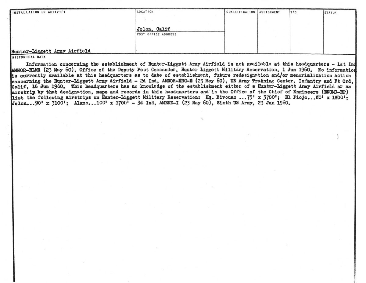
Hunter Liggett Army AIrfield
Tusi Army Airfield
A landing/takeoff area for helicopters is located at Tusi Army Airfield within Fort Hunter Liggett, California. Tusi Army Heliport [AH] is a US Army Reserve asset which is under the Air Traffic Services Command (ATSCOM) at Fort McPherson, GA.
Tusi Army Heliport is named for Chief Warrant Officer (W2) Ronald L. Tusi, one of Army Aviation’s most outstanding attack helicopter pilots. During five tours in the Republic of Vietnam, he earned the Distinguished Service Cross, four Silver Stars, eight Distinguished Flying Crosses, three Bronze Stars (one with “V” device), 67 Air Medals, the Vietnamese Cross of Gallantry with Gold Star, and the American Legion Aviation Award for Valor in 1972. CW2 Tusi’s brilliant aviation career was cut short by his untimely death in a Cobra accident on the night of 6 August 1974. He was participating at the time in the dangerous “Night Owl” experiments which were used as a basis for today’s night fighting techniques.
At the time of his Army Aviation Hall of Fame induction in 1983, CW2 Tusi’s record of killing ten tanks with helicopters had never been equaled, and he was considered to be Army Aviation’s leading tank killer
|
|
|
|
| 7 December 1941 |
|
|
| Army of the United States Station List | 1 June 1943 |
|