
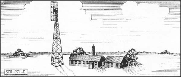
The Klamath River Radar Station B-71 in Redwood National Park, California, is a rare survivor of a World War II early-warning radar station, the first step toward the more sophisticated and pioneering early-warning radar defense network. Rather than using camouflage materials, the buildings of Radar Station B-71 were constructed to resemble farm buildings to disguise their true purpose. The station consists of three buildings: a power building disguised as a farmhouse, an operations building disguised as a barn and a functional wood frame two-stall privy or outhouse, now a partially collapsed ruin. The two major buildings were constructed for the Army by a private contractor specifically for the early warning aircraft station, and consist of block walls roughly two feet thick covered with wood-framed gable roofs with wood shingle finish.
As a result of the attack on Pearl Harbor and in the Aleutian Islands, the necessity of guarding American coastlands became more urgent on the Pacific Coast than on the Atlantic. The threat was further demonstrated when a Japanese submarine shelled an oil refinery north of Santa Barbara, California, on February 23, 1942. Another Japanese submarine shelled Esteven Point in British Columbia, Canada, on June 20, 1942, and again at Fort Stevens, Washington, on July 21, 1942. On September 9, 1942, a Japanese submarine-launched aircraft dropped incendiary bombs on Oregon forests roughly 40 miles north of the Klamath River. The radar station south of the Klamath River, in what is now Redwood National Park, was built in late 1942 and early 1943 as the northernmost California station in a network of 72 proposed stations, 65 of which were actually built, stretching from the Canadian border into Mexico. The Klamath station was designated by memorandum dated November 6, 1942, from the Office of the Commanding General, IV Fighter Command, as Station B-71, named "Trinidad." It was also referred to as the "Klamath River" station.

The station was manned by members of the Army Air Corps quartered
in barracks near the town of Klamath. One day's operation of the
station required a crew of about 35 men to cover the 24 hours
in shifts. The station reported by direct telephone to an Aircraft
Warning Service Filter Office in Berkeley, California. As the
threat of Japanese attack waned towards the end of World War II,
the coastal early radar stations began to be phased out. But with
the need for early-warning radar decreasing, the need for air-sea
rescue radar increased, and effective July 1, 1944, the Klamath
station was converted to emergency rescue service, with the SCR-271
radar replaced with the RC-150 IFF equipment. Station B-71 was
thus one of only 22 radar stations on the Pacific Coast, which
remained operational until the end of World War II. Station B-71
was abandoned and reverted to private ownership after the war,
until the National Park Service acquired it with the creation
of Redwood National Park.
Located in Redwood National Park in Northern California, Radar Station B-71 is located on Coastal Dr., just south of the mouth of Klamath River. From the south, take Newton B. Drury Scenic Pkwy. to Coastal Dr. (trailers and motor homes not permitted). A trail leads to the station from the road, although the buildings are not open. The park headquarters is located at Second and K sts. in Crescent City. Visit the park's website or call 707-464-6101 ext. 5064 for further information.

The Radar station south of the Klamath River,
in what is now Redwood National Park, was built in late 1942 and
early 1943 as the northernmost California station in a network
of 72 proposed stations (65 of which were actually built) stretching
from the Canadian border into Baja Mexico. The Klamath Station
was designated by a memorandum dated November 6, 1942 from the
Officer of the Commanding General, IV Fighter Command, as Station
B-71, named "Trinidad." It was also referred to as the
"Klamath River" Station.
The Station was located approximately two miles south of the mouth of the Klamath River on a flat shelf about 250 feet above the Pacific Ocean and 100 feet below the dirt road along the coast, at a point southeast of Flint Rock Head and northeast of White Rock. Before the Station was built the site was crossed by the old and long-abandoned Trinidad-Klamath wagon road, which descends northward through the Station to the mouth of the Klamath River. The road is thoroughly overgrown with brush, vines and grasses, as is the vicinity of the Radar Station.
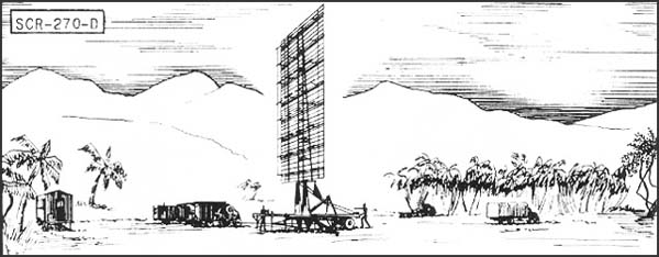
The Station appears to have been initially equipped in July 1943 with an SCR-270B portable long-range (120 to 150 mile) Radar system moved in from its previous location at station B-38 on Santa Rosa Island, one of two Radars stationed on that island. Between December 1943 and April 1944, the SCR-270B was replaced with a permanent SCR-271 system. During the first half of 1943, a mobile SCR-270B Radar antenna consisted of a rectangular metal grid mounted vertically on a pole of triangular metal framework. The whole assembly was carried on a wheeled trailer. The layered metal grid antenna reminded some of a set of gigantic metal bedsprings.
The Station consisted of two major buildings, one of which housed the power generating equipment and disguised to look like a farmhouse, and the operating buildings with the displays and electronics disguised to look like a barn. There was also a two-hole privy. A private construction firm under Army contract erected the buildings and their camouflage features were built-in, including false wooden siding and false windows over concrete-block construction, and false dormer windows on the power-building roof. From the air, the station appeared to be a farm with barn, except for the portable Radar located in 1943 in the open and uncamouflaged about thirty feet west of the operating building.
The Station was manned by members of the Army Air Corps quartered in barracks near the town of Klamath. It was commanded during part of 1943 by a 2nd Lieutenant Neff. On days of operation the Station required a crew of about 35 men to cover the 24 hours in shifts. The Station reported by direct phone to an Aircraft Warning Service Filter Office in Berkeley, California. The Station was guarded by a detachment of military police, with rifles and trained guard dogs. It was protected by three 50-caliber machine guns on anti-aircraft mounts located in 12 feet diameter concrete circular pits 100 feet from the buildings. All of the Army Air Corps men also carried rifles and the Station had one submachine gun.
Effective July 1, 1944 the Station was converted
to emergency rescue service with the SCR-271 replaced with and
RC-150 Identification Friend or Foe (IFF) equipment. Station B-71
was one of only 22 radar stations on the Pacific Coast, which
remained operational until the end of World War II.
The site is listed on the National Register of Historic Places
because it is an example of a World War II early warning Radar
station.
References: Redwood National and State Parks, Historic Site Description, James O'Barr, Park Curator, Crick, California.
| Altitude, feet | 1000 | 5000 | 20,000 | 25,000 |
| Range, miles | 20 | 50 | 100 | 110 |
| Altitude, feet | 1000 | 5000 | 20,000 | 25,000 |
| SCR-271-E Range, miles | 20 | 50 | 100 | 110 |
| SCR-271-D Range, miles | 25 | 60 | 120 | 135 |
Additional Online Histories
Historic American Engineering Report
Extract,
War Department Inventory of Owned, Sponsored and Leased Facilities,
1945