US Army Corps
of Engineers Los Angeles District History (1994)
The Point Vincente Military Reservation and Fire Control Sites
were located adjacent to Fort MacArthur, 13 miles west of Long
Beach, California and consisted of 280.77 acres acquired by the
War Department as part of the Harbor Defenses of Los Angeles.
The Military Reservation subsequently was designated as Los Angeles
Defense Area LA-55, a Cold War air defense missile site and is
covered under a separate history.
The Point Vincente Military Reservation
consisted of two (2) tracts totaling 107.77 acres. Of the 107.77
acres, 107.55 acres were purchased from the Palos Verdes Corporation
in January 1942, and 0.22 acres were acquired by oral permit
from the US Coast Guard. The date of acquisition of the property
by the US Coast Guard could not be determined.
The Fire Control Sites consisted of seventeen
(17) tracts totaling 173.00 acres. Of the 173.00 acres, 6.24
acres were acquired by use permit from the Palos Verdes Corporation,
157.55 acres were leased from the Palos Verdes Corporation, and
9.21 acres were leased from the Filiorium Corporation.
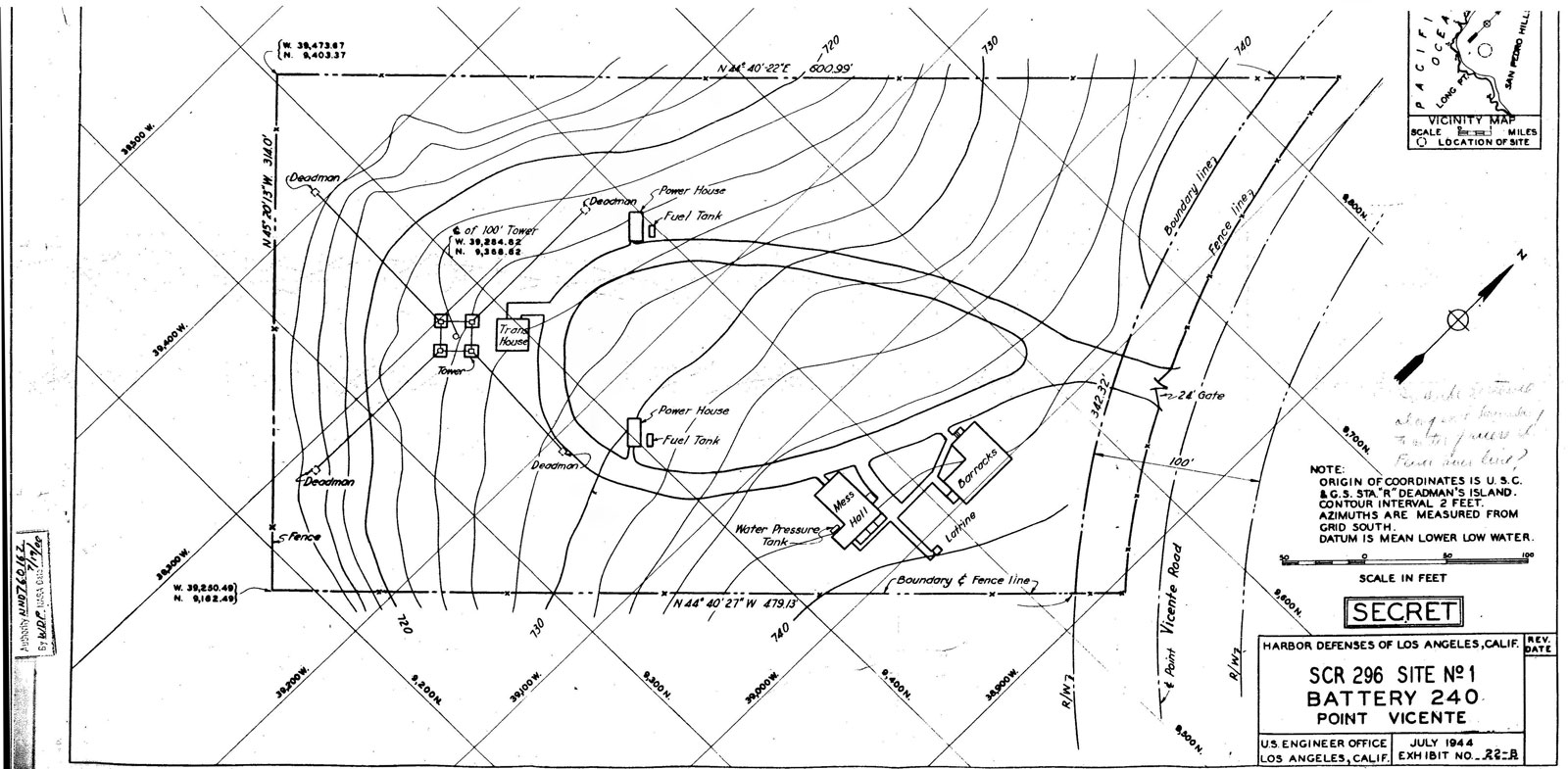
Improvements on the 107.77 acre Point Vincente Military Reservation
included the gun mounts and concrete/steel bunker comprising
Battery No. 240 and twenty-four (24) supporting buildings or
structures near Hawthorne Boulevard. Battery No. 240 contained
two underground storage tanks (USTs) enclosed in concrete vaults.
The Administrative and Launcher areas for Los
Angeles Defense Area LA-55 was also constructed on the Point
Vincente Military Reservation at a later date. The launcher area
contained two underground missile magazines, missile elevators
and launch pads for the Nike-Ajax and later the Nike-Hercules
air defense missiles.
For the seventeen (17) Fire Control Sites, improvements on six
(6) of these tracts, comprising 72.99 of the 173.00 acres, included
three (3) Signal Corps Radio (SCR) radar sites (two of which
are included in this history), two (2) fire control sites, and
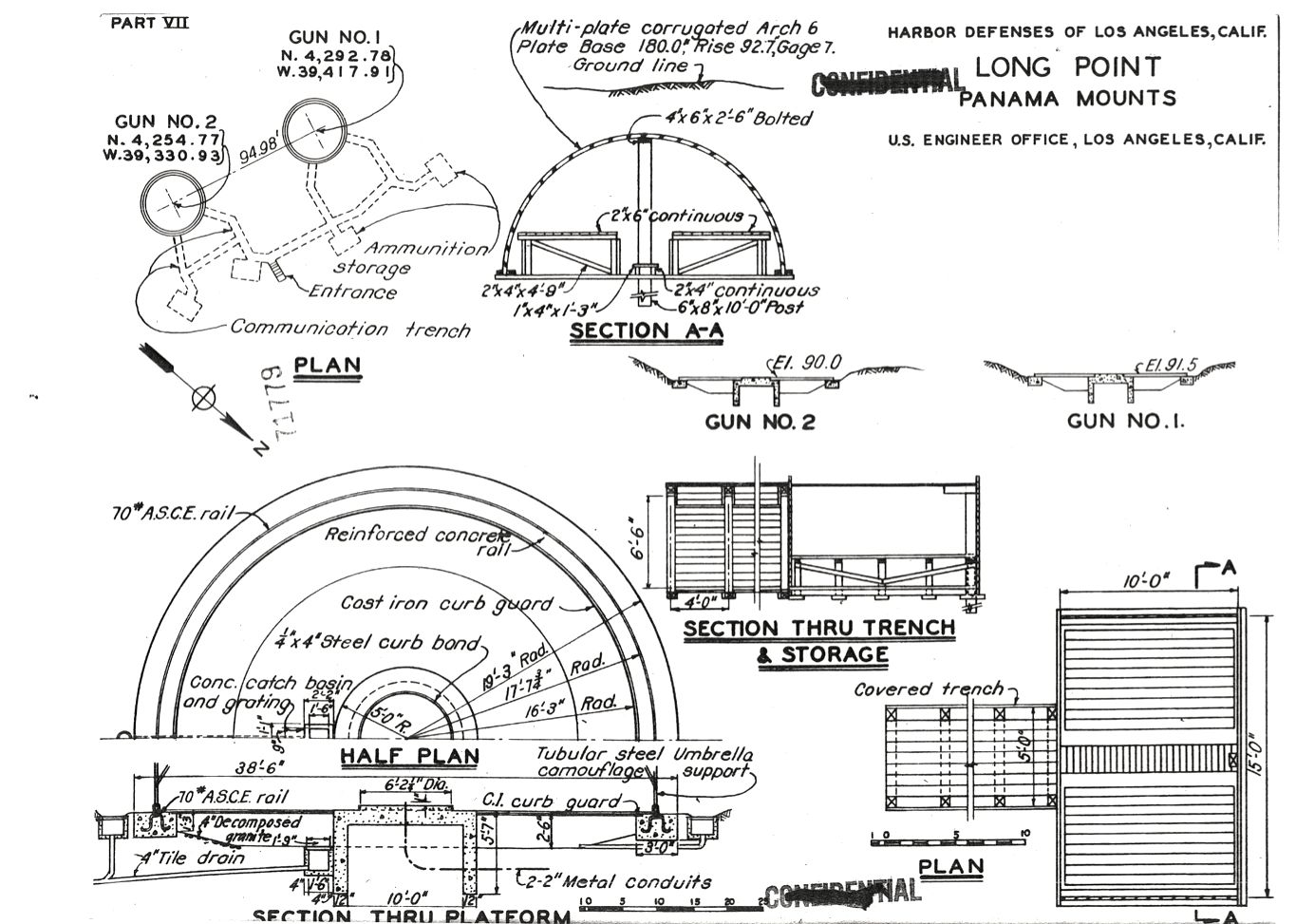
Panama gun mounts (a separate history as Long
Point Military Reservation) with a searchlight. Buildings
and structures included an observation tower, a transmitter building,
two (2) power buildings, and two (2) two-level dug-ins. Other
improvements included electricity via engine generators, telephone,
and two above-ground storage tanks. The remaining eleven (11)
tracts were either developed as access roads or were undeveloped.
The property comprising the Point Vincente
Military Reservation was disposed in six transactions. The 0.22
acres were returned to the U.S. Coast Guard in August 1947 and
were incorporated into the Point Vincente Lighthouse Reservation.
In July 1950, 0.28 acres were transferred to the U.S. Coast Guard,
and on October 1959, 4.67 acres were transferred to the U.S.
Coast Guard for incorporation into the Point Vincente Lighthouse
Reservation. An additional 16.54 acres were transferred (transaction
date unknown) to the U.S. Coast Guard and were converted into
a radio antenna station. In March 1957, 10.53 acres were transferred
to the County of Los Angeles via quitclaim deed and were developed
as the Point Vincente County Park. In October 1979, 75.53
acres were transferred to the City of Rancho Palos Verdes via
quitclaim deed and were converted into the site of the Rancho
Palos Verdes City Hall.
The six (6) tracts upon which fire control sites were constructed
were disposed in five separate transactions. The lease for 13.86
acres comprising Fire Control Site No.4 and Searchlight No. 10
site was terminated in September 1944. The lease for 25.77 acres
comprising Panama Gun Mounts site was terminated in October 1944.
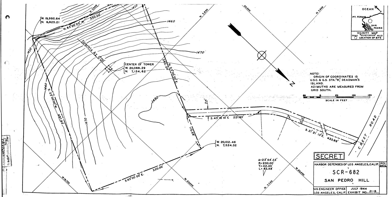
The lease for 7.00 acres comprising SCR 682 Site A was terminated
in February 1947. The lease for 2.34 acres comprising Fire Control
Site No. 3 was terminated in June 1950. The leases for 4.36 acres
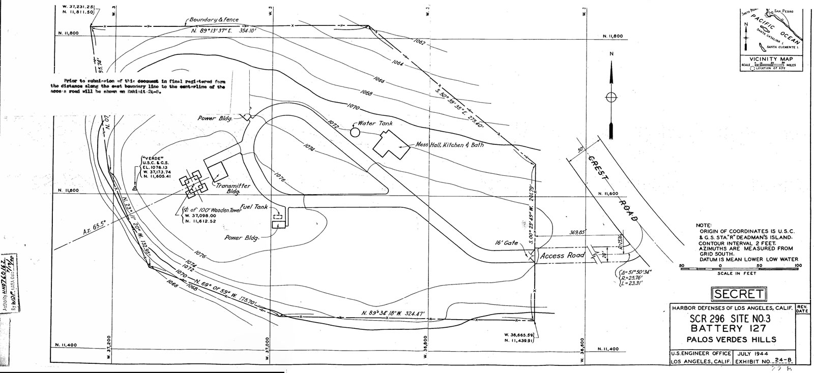
comprising SCR 296 Site No. 3-B and 19.66 acres comprising SCR
296 Site No. 1 were terminated in June 1952. The sites are currently
private residences, recreational facilities, or roadways.
Leases for the remaining ten (10) leased tracts were terminated
as follows: 5.85 acres in October 1944, 0.11 acres in June 1946,
3.54 acres in August 1946, 17.66 acres in November 1946, 26.36
acres in July 1947, 0.52 acres in August 1947, 39.73 acres in
June 1952. The tracts are currently private residences, recreational
facilities, or roadways. The remaining 6.24 acres tract, which
was used with the permission of Palos Verdes Corporation, was
returned and is presently Hawthorne Boulevard immediately prior
to Rancho Palos Verdes Drive.
US Army Corps
of Engineers Los Angeles District History (1993)
Location The Point
Vincente Military Reservation straddled Palos Verdes Drive and
Hawthorne Boulevard at Point Vincente in Rancho Palos Verdes,
California, 13 miles west of Long Beach, California. The Fire
Control Sites were spread across the southern portion of the
Palos Verdes peninsula.
Site History: The Point
Vincente Military Reservation and Fire Control Sites were established
by the U.S. Army as part of the harbor defenses of Los Angeles
between 1942 and 1945. The site consisted of nineteen (19) tracts
distributed over a 10 square mile area. The Military Reservation
was subsequently incorporated into the Los Angeles Defense Area
as Los Angeles Defense Area Site 55, here after a separate
history.
The Point Vincente Military Reservation
consisted of two (2) tracts: 107.55 acres purchased from the
Palos Verdes Corporation and 0.22 acres used with the permission
of the United States Coast Guard (USCG). The Military Reservation
was initially developed with the construction of a 6-inch coastal
defense gun battery (Battery No. 240) and a searchlight (Searchlight
No.8). Twenty-four (24) buildings or structures were constructed
near Hawthorne Boulevard. Two (2) underground storage tanks (USTs)
were located on the 107.55 acre parcel. An Administrative and
Launcher areas for Los Angeles Defense Area Site 55 was constructed
on the Military Reservation in the early 1950s. One (1) other
UST was located at the Administrative/Launcher area and was previously
removed by the City of Rancho Palos Verdes.
The property comprising the Point Vincente Military Reservation
was disposed in six transactions. The 0.22 acres were returned
to the U.S. Coast Guard in August 1947 and were incorporated
into the Point Vincente Lighthouse Reservation. In July 1950,
0.28 acres were transferred to the U.S. Coast Guard, and on October
1959, 4.67 acres were transferred to the U.S. Coast Guard for
incorporation into the Point Vincente Lighthouse Reservation.
An additional 16.54 acres were transferred (transaction date
unknown) to the U.S. Coast Guard and were converted into a radio
antenna station. In March 1957, 10.53 acres were transferred
to the County of Los Angeles via quitclaim deed and were developed
as the Point Vincente County Park. In October 1979 75.53
acres were transferred to the City of Rancho Palos Verdes via
quitclaim deed and were converted into the site of the Rancho
Palos Verdes City Hall.
Fire Control Sites: The remaining seventeen
(17) tracts, comprising 173 acres, were leased from (166.76 acres),
or used with the permission of (6.24 acres), the Palos Verdes
Corporation (16
tracts) and the Filiorium Corporation (1 tract) for potential
use as fire control sites. Of these 17 tracts, coastal defense
installations were developed on only six (6) tracts. These installations
consisted of three (3) Signal Corps Radio (SCR) radar sites,
two (2) fire control sites, and Panama gun mounts with a searchlight.
Buildings and structures included an observation tower, a transmitter
building, two (2) power buildings, and two (2) two-level dug-ins.
The six (6) tracts upon which fire control sites were constructed
were disposed in five separate transactions.
The lease for 13.86 acres comprising Fire Control Site No.4 and
Searchlight No. 10 site was terminated in September 1944. The
lease for 25.77 acres comprising Panama Gun Mounts site was terminated
in October 1944. The lease for 7.00 acres comprising SCR 682
Site A was terminated in February 1947. The lease for 2.34 acres
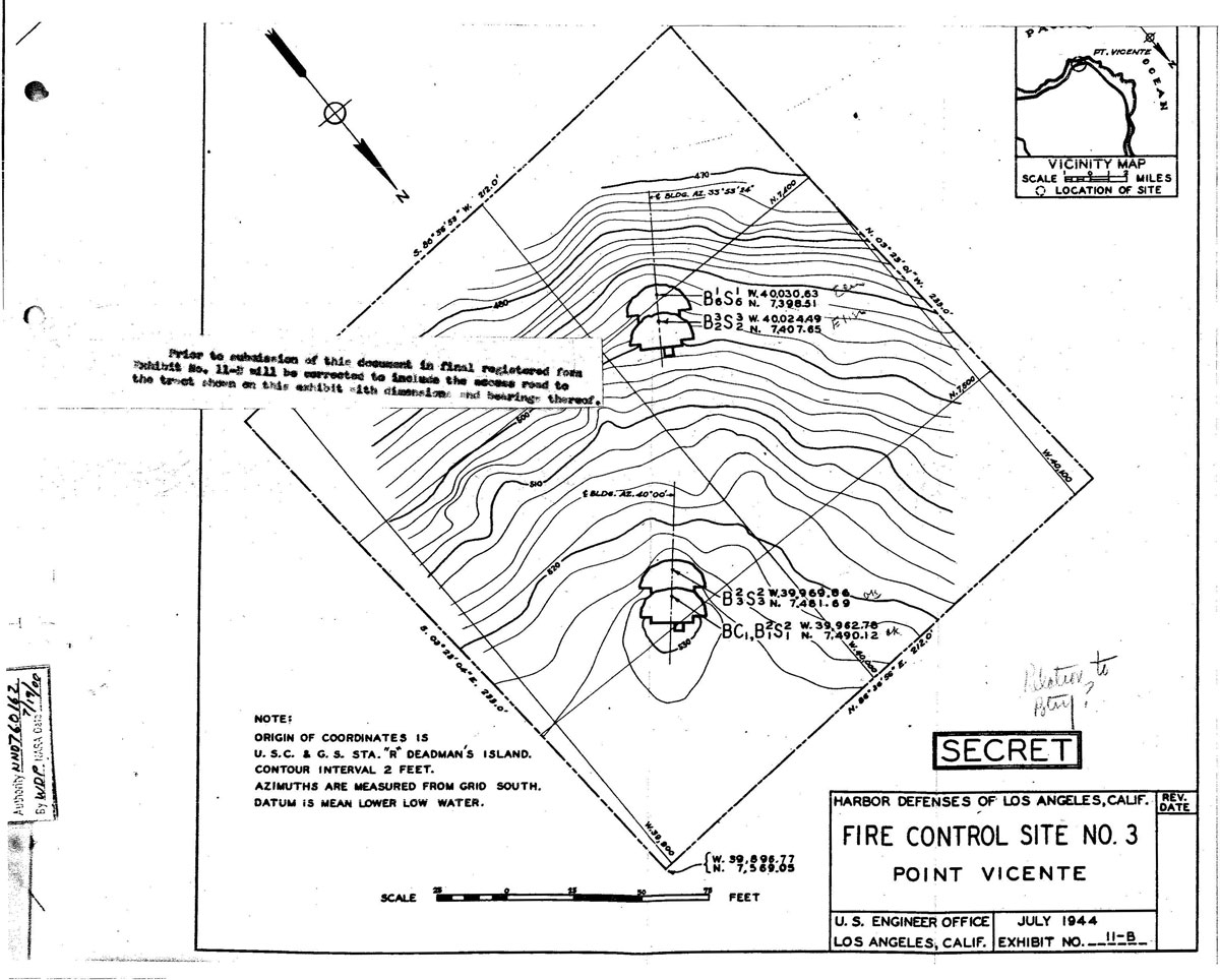
comprising Fire Control Site No.3 was terminated in June 1950.
The leases for 4.36 acres comprising SCR 296 Site No. 3-B and
19.66 acres comprising SCR 296 Site No. 1 were terminated in
June 1952. The sites are currently private residences, recreational
facilities, or roadways.
Ten (10) leased tracts, comprising 93.77
acres, were either developed as access roads or were undeveloped.
Leases for these tracts were terminated between March 1945 and
June 1952. The sites are currently private residences, recreational
facilities, or roadways. The remaining tract, which was used
with the permission of the Palos Verdes Corporation, was returned
and is presently Hawthorne Boulevard.
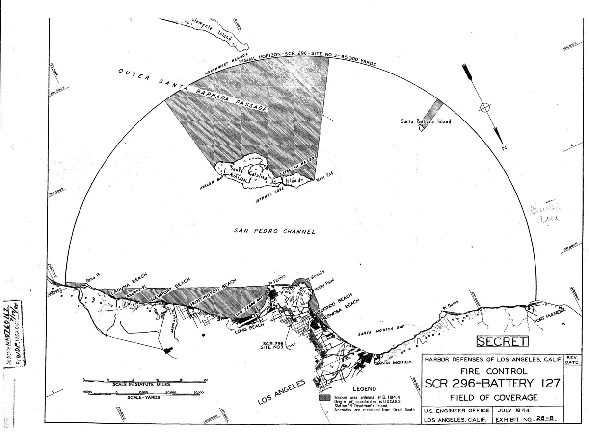
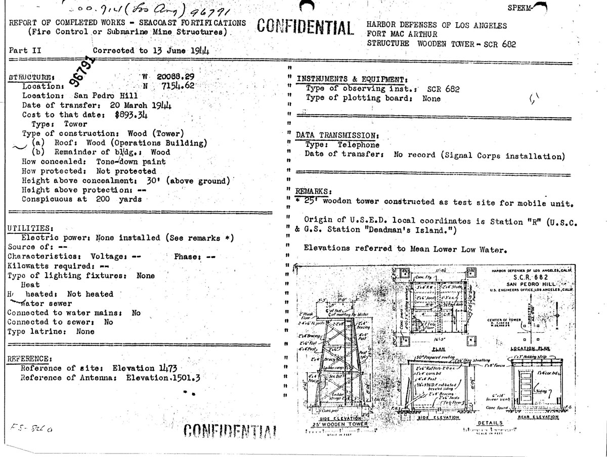
Seacoast
Radar Sets Used
SCR-682 Transportable Microwave
Seacoast Artillery Set
Uses:
Used by 155-mm and 8-inch railway battalions. PPI gives indication
of surface craft and low-flying planes. Uses IFF (Identification
Friend or Foe) RC-282.
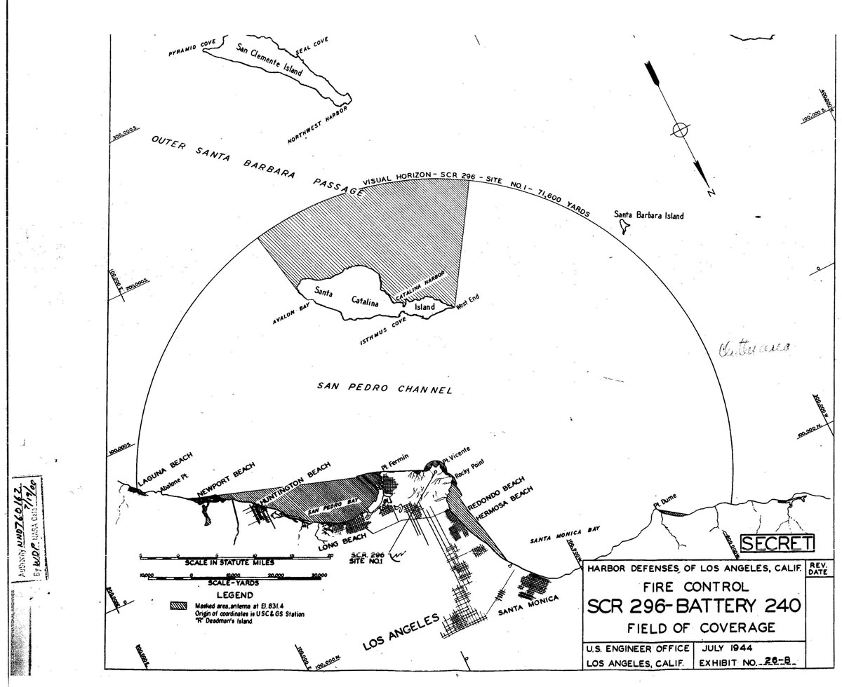
Performance and Siting: Set covers 360°. For a height of 100 feet,
range will average 50,000 yards or greater. At times, under favorable
conditions, very much greater maximum ranges will be achieved
from sufficient heights of site. Minimum range is about 500 yards.
Azimuth accuracy is on the order of ± 2 degrees depending
somewhat on the range scale in use. The range accuracy thus may
be considered ± 3 per cent of the range scale in use.
The range scales are 10,000; 4,000p; 160,000; and 320,000 yards.
Set should be sited not less than thirty feet above the surrounding
terrain and preferably at least 100 feet above sea level. The
optimum height of site is between 150 and 500 feet.
Transportability:
A transportable version of the SCR-582, the SCR-682 can be carried
in two standard 2-1/2-ton 6x6 cargo trucks.
Installation:
Set normally is operated form a portable tower furnished with
set. The operating components are located near the tower in a
Shelter HO-17 or housing constructed by the using troops from
materials obtained locally. No transportation is furnished with
the set.
Personnel: One
man operates the set and another plots the position of detected
targets. These men relieve one another every thirty minutes to
reduce fatigue. For 24-hour operation a chief of section, five
operators, two power plant operators, and one maintenance man
are required.
Power:
Requires about 1.28 KW, 120 V, 60 cycles, single phase.
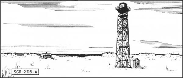
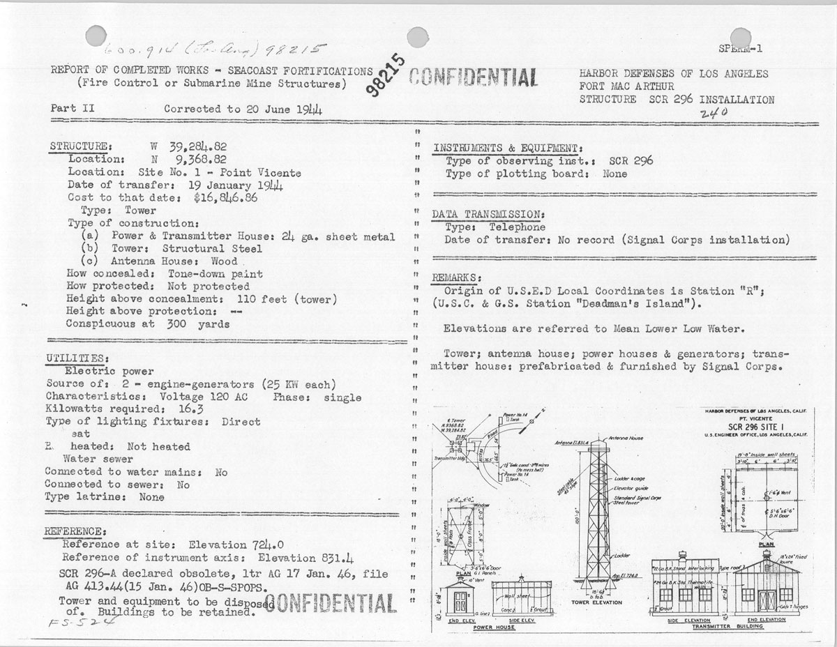
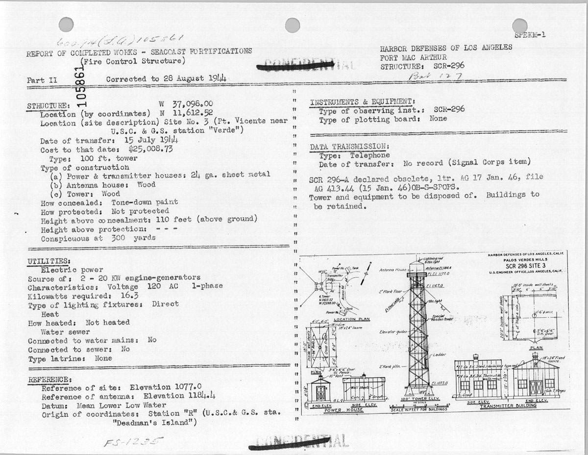
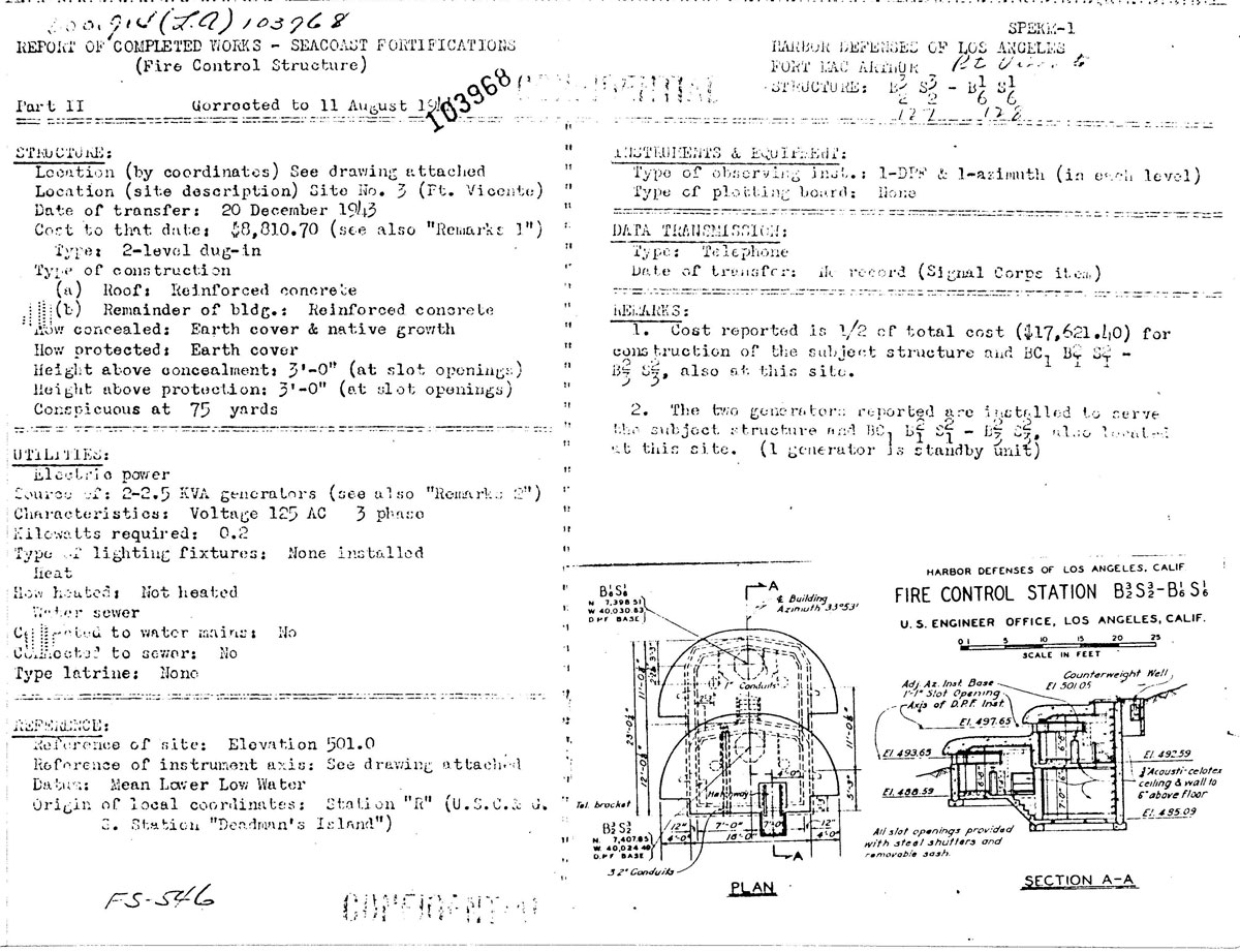
SCR-296 Fixed Coast Artillery Gun-Laying Medium
Wave Radar Set
Description: Fixed
Coast Artillery gun-laying medium wave radar, assigned to modern
6 inch or larger batteries.
Uses: Set
is designed to track a surface target in range and azimuth. Data
are sent to the plotting room and used in firing. An SCR-296-A
normally is assigned to one battery, but may furnish data to more.
Works with IFF RC-136-A.
Performance & Sitting: Range is shown on "A" scope. The target
is tracked in azimuth with a pip matching oscilloscope or a zero-center
meter. Range accuracy is about ± 30 yards while azimuth
accuracy is about ± 0.20 degree under the best conditions.
The set has a dependable range of 20,000 yards on a destroyer
size target when employed at a height of 145 feet. Site should
be not less than 100 feet above sea level; 150 to 500 feet is
recommended.
Mobility: Shipment
includes areas and separate generator. When crated the total weight
is 91,763 lbs. Largest unit is 5,270 lbs.
Installation: SCR-296-A
includes a tower, an operating building, and two power plant buildings.
The tower is obtainable in heights of 25, 50, 75, and 100 feet.
Concrete floors must be put in locally.
Personnel: Operating
crew consists of 5 men in addition to a power plant operator and
maintenance man who should be available at all times.
Power: Primary
power of 2.3 KW is supplied by PE-84C -- commercial or auxiliary
110 V, AC single phase. Generator needs high octane gasoline.