Historic California Posts, Camps,
Stations and Airfields
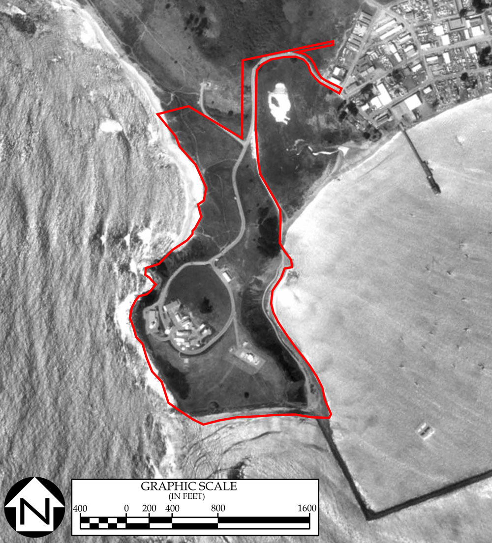
Pillar Point Air Force Station
(Pillar Point Military Reservation,
(including Seacoast Searchlights Nos. 34 and 35, and SCR-296
Radar Set No. 11; Pillar Point Air Station)
Point Pillar AFS
(Image courtesy of the California Coastal Records Project)
US Army Corps of Enginners Sacramento District History (2006)
by Dan Sebby
Pillar Point AFS was initially established
as part of the Harbor Defenses of San Francisco (HDSF). The reservation
consisted of three separate concrete Base End Stations that provided
fire control azimuth data to Battery 244 (two six-inch guns at
Milagra Ridge Military Reservation), Battery Richmond P Davis
(two sixteen-inch guns at Fort Funston), and Battery 129 (two
sixteen-inch guns at Fort Barry). One map shows a location for
a Base End Station for the uncompleted Battery 130 (two sixteen-inch
guns at Milagra Ridge Military Reservation). However, neither
a USACE Report of Completed Works nor documentation transferring
this bunker to the HDSF was located at the National Archives.
In addition to these bunkers, there was a fortified powerhouse
that contained a generator that provided electrical power in
the event that the commercially provided power was interrupted.
In June 1944, an SCR-296 radar set was installed at the Site
in order to provide target detection and ranging data to Battery
Richmond P. Davis at Fort Funston. This installation was located
on the highest point on the Pillar Point and consisted of an
aboveground, prefabricated 20 feet x 20 feet corrugated iron
transmitter house, a 50-feet high TR-46 antenna tower, a power
house and a gasoline tank. This installation was declared obsolete
on 17 January 1946 and the equipment was removed soon thereafter.
Pillar Point AFS also had two searchlight stations (HDSF numbers
34 and 35) and two .50-caliber machine guns for anti-aircraft
defense (HDSF numbers 65 and 66). USACE documents also indicated
that single concealed "hutment" was constructed to
provide housing and messing for sixteen soldiers. This structure
was located approximately 100 feet north of the Base End Station
for Battery 129.
All of the above mentioned installations are within the boundary
of the current Pillar Point AFS.
By 1949, the USACE terminated all of the leases for the land
less 1.05 acres that was retained by the U.S. Army for a right-of-way.
On 4 September 1959, the Department of the Army transferred the
federally owned and leased property to the Department of the
Navy for use as a missile tracing station in support of Point
Mugu. Almost immediately, the U.S. Navy reacquired all but approximately
three acres of the former Coast Artillery Fire Control Station
by lease.
At sometime in the 1960's the Site was transferred to the Department
of the Air Force who assumed the missile tracking responsibilities
from the U.S. Navy. The Site was expanded by condemnation proceedings
to encompass all but seven acres of the Pillar Point AFS, now
known as Pillar Point AFS. Pillar Point AFS is subordinate installation
to Vandenberg AFB's 30th Space Wing.
In the 30th Space Wing Launch Safety Assessment (published February
2000):
The Pillar Point AFS is the northernmost instrumentation site
[of the Western Missile Range].
It is located along the California
coast, south of San Francisco. It's geographical location provides
an aspect angle for launch operations which diminishes challenges
which could result from looking into the flame of an outbound
launch vehicle. Pillar Point also provides extended coverage
off the coast of California for aeronautical tests. It is just
one of the Northern California elements in the total 30th Space
Wing data collection capability. At the Pillar Point facility,
there are two tracking radars: the FPQ-6 and the MPS-36;a telemetry
system that includes a 40 foot antenna; and the CT-4, Command
Control Transmitter. Metric and telemetry data acquired by the
Pillar Point facility is used for real-time decommutation and
display as well as post flight processing.
The 40 foot antenna uses an elevation
over azimuth pedestal. The system is capable of automatically
tracking any inter-Range Instrumentation Group, telemetry modulation
in the L-band and upper and lower S-band frequencies. This telemetry
antenna provides a valuable "side-look" during Vandenberg
launches.
The FPQ-6 C-band Radar is a high accuracy,
long range, amplitude comparison monopulse tracking system that
can operate in both skin and beacon modes. It is of the Missile
Precision Instrumentation Radar class and has undergone various
upgrades to the antenna drive system, console, receiver, transmitter,
and RF feed sections. The antenna is a 20 foot parabolic Cassegranian
reflector supported by an elevation over azimuth pedestal.
The radar subsystems provide the data
handling interface with time, range, azimuth, elevation, doppler
frequency, and radar status information. The radar embedded computer
system formats data for on-site recording, display, and off-site
transmission.
The MPS-36 is a C-band monopulse tracking
radar. It is considered a mobile radar and is contained in three
trailers plus an antenna lowboy. The antenna is a 12 foot parabolic
Cassegranian reflector.
The MPS-36 has an Integrated Circuit
Digital Range system which assists in the acquisition of skin
and beacon targets. Target range, azimuth, elevation data, and
time are output to a console for display, and recorded for post
operation data production.
CT-4 is an operational command control
transmitter site located at Pillar Point to provide additional
command control flexibility for operations. CT-4 is used to support
both Vandenberg and naval operations and can be controlled from
both Vandenberg and Point Mugu. The directional antenna is a
15 foot parabolic dish antenna.
Documentation supports that there were
no buildings, fortifications, or activities in the approximately
seven acres that are not included in the current Pillar Point
AFS.
Globalsecurity.com History
The Pillar Point AN/FPQ-6 and AN/MPS-36
radars are highly accurate G-band radars owned by the VAFB's Western
Range (WR). These radars can be used for tracking objects off
the coast of central California. Data from the Point Mugu and
VAFB metric radars are exchanged over 16 multiplexed channels
for TSPI track and sensor positioning.
The AN/FPQ-6 is a Missile Precision Instrumentation
Radar (MIPIR) class monopulse tracking radar used to provide position
data on aircraft, missiles, space boosters, and orbiting bodies.
The site can track in either skin mode or in conjunction with
vehicle-borne transponders. The radar's large antenna and high
power coherent transmitter make the site's data quality very high.
The sensor can also provide Doppler-derived range rate data on
skin or coherent transponder tracks. Non-owners may utilize the
services of the radar, but site operations and maintenance is
limited to the Western Range contractor.
The Sea Range metric radars provide precise,
accurate tracking of range operation participants using four radars
at Point Mugu and four on SNI. Additional metric tracking support
is available from six Western Range radars located at Vandenberg
Air Force Base (VAFB), Tranquillon Peak and Pillar Point. The
WR radars provide high altitude tracking over the Sea Range and
extend operational support to areas west of VAFB.
The California Coast has few protective
points. Pillar Point is one of them. The Point at night with its
string of lights looks like the largest battleship in the American
fleet. On top of the point is the Pillar Point Air Force Station.
Beneath the tracking station is the harbor. It is the only harbor
between San Francisco and Santa Cruz. This natural harbor has
been used by coastal fishermen for centuries, but the harbor,
with its tracings of rip-rap breakwaters, was first constructed
in 1961. The inner breakwater was added in 1982.
Source globalsecurity.org.
Used with permission
US Army Corps of Engineers Sacramento
District History
On 10 October 1940, the U.S. Army purchased
12.68 acres and leased 36.28 acres. The total acreage acquired
for the subject site was 48.96 acres.
The site was known as Pillar Point Military
Reservation (Harbor Defense of San Francisco [HDSF]), California.
The site was situated in San Mateo County, 15 miles south of the
City of San Francisco. The site was used as a harbor defense facility
and primary artillery site for the City of San Francisco. The
improvements constructed at Pillar Point consisted of barracks,
concrete bunkers, cyclone fences, and an overhead and underground
electric system.
On 30 November 1949, the lease on 34.17
acres terminated. On 30 June 1953, the lease on 1.06 acres terminated.
On 04 September 1959, the lease on 1.05 acres terminated, the
12.68 acres originally purchased by the U.S. Army were transferred
to the Department of the Navy. The 36.28 acres were again leased
in 1959 by the U.S. Navy for use as a radar facility. In the early
1960s the 12.68 purchased acres were transferred to the U.S. Air
Force and a missile tracking installation was established on the
site. The property owned by the U.S. Air Force continues to be
used as part of the missile tracking installation. Four of the
remaining seven acres are currently owned by the San Mateo Harbor
District and are being developed into a wetlands habitat. The
remaining three acres are privately owned and undeveloped.
Source: US Army Corps of
Engineers
Site Map, Pillar Point Military Reservation,
HDSF
Site Map, Pillar Point AFS
Reports of Completed Works - Seacoast
Fortifications
Fire Control Structure for
Battery Construction No. 129 (Fort Barry)
Fire Control Structure, Battery
Davis (Fort Funston)
Fire Control Structure, Battery
Contruction No. 244 (Milagra Ridge Military Reservation)
SCR-296 Seacoast Radar for
Battery Davis (Fort Funston)
SCR-296 Radar
Description:
Fixed Coast
Artillery gun-laying medium wave radar, assigned to modern 6
inch or larger batteries.
Uses:
Set is designed
to track a surface target in range and azimuth. Data are sent
to the plotting room and used in firing. An SCR-296-A normally
is assigned to one battery, but may furnish data to more. Works
with IFF RC-136-A.
Performance
& Sitting:
Range is shown
on "A" scope. The target is tracked in azimuth with
a pip matching oscilloscope or a zero-center meter. Range accuracy
is about ± 30 yards while azimuth accuracy is about ±
0.20 degree under the best conditions. The set has a dependable
range of 20,000 yards on a destroyer size target when employed
at a height of 145 feet. Site should be not less than 100 feet
above sea level; 150 to 500 feet is recommended.
Mobility:
Shipment includes
areas and separate generator. When crated the total weight is
91,763 lbs. Largest unit is 5,270 lbs.
Installation:
SCR-296-A includes
a tower, an operating building, and two power plant buildings.
The tower is obtainable in heights of 25, 50, 75, and 100 feet.
Concrete floors must be put in locally.
Personnel:
Operating crew
consists of 5 men in addition to a power plant operator and maintenance
man who should be available at all times.
Power:
Primary power
of 2.3 KW is supplied by PE-84C -- commercial or auxiliary 110
V, AC single phase. Generator needs high octane gasoline.


-Point-Montara-Pilar-Point.jpg)